
Spenden
Topografische Karte Vitória da Conquista
Klicken Sie auf die Karte, um die Höhe anzuzeigen.
Spenden
Vitória da Conquista
The city has a subtropical highland climate (Cfb/Cfa/Cwb/Cwa, according to the Köppen climate classification), relatively dry and moderated in temperature by the elevation. It closely borders a tropical savanna climate (Aw). The altitude of the city itself varies between 857 meters (2811 feet) and 950 meters (3116 feet). Precipitation from April to August is often characterized by fine, misty rain, while heavier rains fall from October to March. Winters (July through October) tend to lack much precipitation but are cool and humid, with cold air coming up to the plateau from the ocean and often producing fog.
Spenden
Über diese Karte
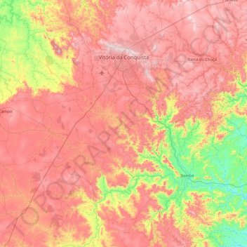
Name: Topografische Karte Vitória da Conquista, Höhe, Relief.
Durchschnittliche Höhe: 727 m
Minimale Höhe: 273 m
Maximale Höhe: 1.115 m
Spenden
Andere topografische Karten
Klicken Sie auf eine Karte, um ihre Topografie, ihre Höhe und ihr Relief anzuzeigen.
Chapada Diamantina
The Chapada Diamantina lies at the center of Bahia State and forms the northern part of the Espinhaço Mountain Range. The region is approximately 38,000 km2 (15,000 sq mi) in area and encompasses 58 municipalities. Technically, this region is considered a part of the caatinga biome, and contains some of its…
Durchschnittliche Höhe: 1.390 m
Costa do Sauípe
Brazil > Bahia > Região Metropolitana de Salvador > Mata de São João
Durchschnittliche Höhe: 10 m
Spenden
Chapada Diamantina
The Chapada Diamantina lies at the center of Bahia State and forms the northern part of the Espinhaço Mountain Range. The region is approximately 38,000 km2 (15,000 sq mi) in area and encompasses 58 municipalities. Technically, this region is considered a part of the caatinga biome, and contains some of its…
Durchschnittliche Höhe: 1.390 m
Praia do Forte
Brazil > Bahia > Região Metropolitana de Salvador > Mata de São João
Durchschnittliche Höhe: 5 m
Spenden
Chapada Diamantina
The Chapada Diamantina lies at the center of Bahia State and forms the northern part of the Espinhaço Mountain Range. The region is approximately 38,000 km2 (15,000 sq mi) in area and encompasses 58 municipalities. Technically, this region is considered a part of the caatinga biome, and contains some of its…
Durchschnittliche Höhe: 1.390 m
Spenden
Serra do Cipó
Brazil > Bahia > Região Metropolitana de Feira de Santana > Ipecaetá
Durchschnittliche Höhe: 254 m
Campos
Brazil > Bahia > Região Administrativa Integrada de Desenvolvimento do Polo Petrolina e Juazeiro > Juazeiro
Durchschnittliche Höhe: 387 m
Spenden
Spenden