
Topografische Karte Ticao Island
Interaktive Karte
Klicken Sie auf die Karte, um die Höhe anzuzeigen.
Über diese Karte
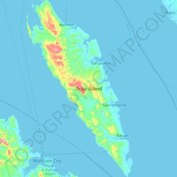
Name: Topografische Karte Ticao Island, Höhe, Relief.
Ort: Ticao Island, Masbate, Bicol Region, 5417, Philippines (12.33834 123.57895 12.69393 123.80057)
Durchschnittliche Höhe: 23 m
Minimale Höhe: -1 m
Maximale Höhe: 411 m
Andere topografische Karten
Klicken Sie auf eine Karte, um ihre Topografie, ihre Höhe und ihr Relief anzuzeigen.
Maingaran
Philippines > Masbate > Masbate City
Maingaran, Masbate City, Masbate, Bicol Region, 5400, Philippines
Durchschnittliche Höhe: 51 m
Palani
Palani, Masbate, Bicol Region, 1524, Philippines
Durchschnittliche Höhe: 11 m
Masbate City
Masbate City, Masbate, Bicol Region, 5400, Philippines
Durchschnittliche Höhe: 68 m
Masbate Island
Masbate Island, Masbate, Bicol Region, 5410, Philippines
Durchschnittliche Höhe: 40 m
Tutuban
Philippines > Masbate > Tutuban
Tutuban, Masbate, Bicol Region, 5417, Philippines
Durchschnittliche Höhe: 38 m
Halabangbaybay
Philippines > Masbate > San Pascual > Halabangbaybay
Halabangbaybay, San Pascual, Masbate, Bicol Region, 5420, Philippines
Durchschnittliche Höhe: 36 m
Mount Bagacay
Philippines > Masbate > Tuybo
Mount Bagacay, Tuybo, Masbate, Bicol Region, Philippines
Durchschnittliche Höhe: 165 m
Uson
Philippines > Masbate > Uson
Uson, Bangad, Masbate, Bicol Region, Philippines
Durchschnittliche Höhe: 25 m
GiGi ....Gallunggung
Philippines > Masbate > Masbate City > Mongahay
GiGi ....Gallunggung, Mongahay, Masbate City, Bangad, Masbate, Bicol Region, Philippines
Durchschnittliche Höhe: 47 m
Famosa
Philippines > Masbate > Famosa
Famosa, Bangad, Masbate, Bicol Region, Philippines
Durchschnittliche Höhe: 13 m
Lumbia
Philippines > Masbate > Lumbia
Lumbia, Bangad, Masbate, Bicol Region, Philippines
Durchschnittliche Höhe: 30 m