
Topografische Karte Parma
Interaktive Karte
Klicken Sie auf die Karte, um die Höhe anzuzeigen.
Über diese Karte
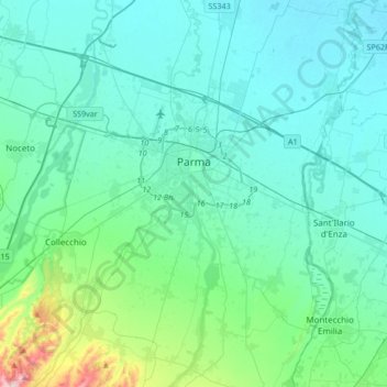
Name: Topografische Karte Parma, Höhe, Relief.
Ort: Parma, Emilia-Romagna, Italy (44.66240 10.21481 44.90074 10.44364)
Durchschnittliche Höhe: 85 m
Minimale Höhe: 23 m
Maximale Höhe: 486 m
During World War II, Parma was a strong centre of partisan resistance. The train station and marshalling yards were targets for high altitude bombing by the Allies in the spring of 1944. Much of the Palazzo della Pilotta, situated not far (half a mile) from the train station, was destroyed. Along with it the Teatro Farnese and part of the Biblioteca Palatina were destroyed by Allied bombs; some 21,000 volumes of the library's collection were lost. Several other monuments were also damaged: Palazzo del Giardino, Steccata and San Giovanni churches, Palazzo Ducale, Paganini theater and the monument to Verdi. However, Parma did not see widespread destruction during the war. Parma was liberated from the German occupation (1943–1945) on 26 April 1945 by the partisan resistance and the Brazilian Expeditionary Force.