
Vielen Dank für die Unterstützung dieser Website ❤️
Spenden
Spenden
Topografische Karte Tahuata
Klicken Sie auf die Karte, um die Höhe anzuzeigen.
Vielen Dank für die Unterstützung dieser Website ❤️
Spenden
Spenden
Tahuata
The land area of Tahuata is 61.0 km2 (23.6 sq mi). The highest point on the island is Mount Amatea (French: Mont Amatea), rising to an elevation of 1,050 m (3,445 ft.). The island is very mountainous, with deep valleys and cliffs. The orography does not allow the construction of an airstrip and communications are by sea from the neighboring island of Hiva Oa, separated by the Bordelais channel 3 km wide and currents of 2 knots.
Vielen Dank für die Unterstützung dieser Website ❤️
Spenden
Spenden
Über diese Karte
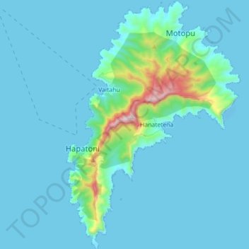
Name: Topografische Karte Tahuata, Höhe, Relief.
Durchschnittliche Höhe: 80 m
Minimale Höhe: -8 m
Maximale Höhe: 918 m
Vielen Dank für die Unterstützung dieser Website ❤️
Spenden
Spenden