
Topografische Karte Roxas
Klicken Sie auf die Karte, um die Höhe anzuzeigen.
Roxas
The landscape of Roxas is relatively compose of flatlands with minimal rise at certain point with base mountain elevations on the eastern part, on the parts of Sinamar, Simimbaan and San Placido. It is approximately 90% of the land area comprising the town can be described as low-lying hills with rolling terrain and an elevation of 200 feet or 61 meters above sea level. The town is dissected by creeks, river and waterways acting as natural drainage from waters coming from the uplands. The Siffu River, a connection from Ilog ng Cagayan(Cagayan River) traverse west ward from its diversion from Paracelis to Tuguegarao City supplying the rice fields with irrigation.
Über diese Karte
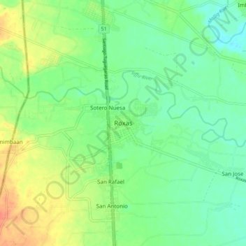
Name: Topografische Karte Roxas, Höhe, Relief.
Ort: Roxas, Isabela, Cagayan Valley, 3320, Philippines (17.08192 121.57992 17.16192 121.65992)
Durchschnittliche Höhe: 59 m
Minimale Höhe: 42 m
Maximale Höhe: 86 m
Andere topografische Karten
Klicken Sie auf eine Karte, um ihre Topografie, ihre Höhe und ihr Relief anzuzeigen.