
Spenden
Topografische Karte Aspet
Klicken Sie auf die Karte, um die Höhe anzuzeigen.
Spenden
Aspet
Located in the middle of the Pyrenees mountain chain, within the ancient region of Comminges, Aspet sits 15 km south to Saint-Gaudens and at the foot of the Cagire (1,912 metres (6,273 ft) in Altitude).
Spenden
Über diese Karte
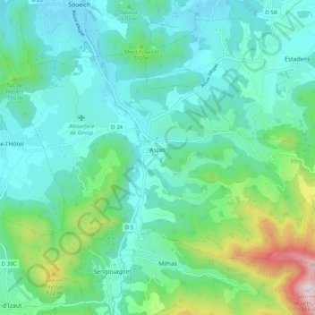
Name: Topografische Karte Aspet, Höhe, Relief.
Durchschnittliche Höhe: 583 m
Minimale Höhe: 385 m
Maximale Höhe: 1.340 m
Spenden
Andere topografische Karten
Klicken Sie auf eine Karte, um ihre Topografie, ihre Höhe und ihr Relief anzuzeigen.
Spenden
Toulouse
France > Occitania > Haute-Garonne > Toulouse
The first half of the 14th century was a prosperous period, despite the dismemberment in 1317 of the very large bishopric of Toulouse (which lost two thirds of its area and a large part of its income, a loss only partially compensated by its elevation to the rank of archbishopric), and the episode of the…
Durchschnittliche Höhe: 173 m