
Topografische Karte Mullaghanish
Interaktive Karte
Klicken Sie auf die Karte, um die Höhe anzuzeigen.
Über diese Karte
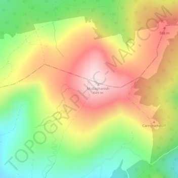
Name: Topografische Karte Mullaghanish, Höhe, Relief.
Ort: Mullaghanish, Blarney - Macroom, County Cork, Munster, Ireland (51.98221 -9.14568 51.98231 -9.14558)
Durchschnittliche Höhe: 474 m
Minimale Höhe: 296 m
Maximale Höhe: 649 m
Andere topografische Karten
Klicken Sie auf eine Karte, um ihre Topografie, ihre Höhe und ihr Relief anzuzeigen.
Newcestown
Newcestown, Murragh, Blarney - Macroom, County Cork, Munster, Ireland
Durchschnittliche Höhe: 156 m
Aherla
Aherla, Kilbonane, Blarney - Macroom, County Cork, Munster, Ireland
Durchschnittliche Höhe: 84 m
Blarney
Blarney, Blarney - Macroom, Cork City 2019, County Cork, Munster, T23 VY22, Ireland
Durchschnittliche Höhe: 97 m
Kilcullen
Kilcullen, Blarney - Macroom, County Cork, Munster, Ireland
Durchschnittliche Höhe: 216 m
Liscarrigane
Liscarrigane, Ullanes, Blarney - Macroom, County Cork, Munster, Ireland
Durchschnittliche Höhe: 240 m
Inishcarra
Inishcarra, Carrigrohane Beg, Blarney - Macroom, County Cork, Munster, P31 HY26, Ireland
Durchschnittliche Höhe: 72 m
Clondrohid
Clondrohid, Blarney - Macroom, County Cork, Munster, Ireland
Durchschnittliche Höhe: 151 m
Cloghduff
Cloghduff, Moviddy, Blarney - Macroom, County Cork, Munster, Ireland
Durchschnittliche Höhe: 101 m
Seefin
Seefin, Blarney - Macroom, County Cork, Munster, Ireland
Durchschnittliche Höhe: 384 m
Killumney
Killumney, Ballygroman, Blarney - Macroom, County Cork, Munster, Ireland
Durchschnittliche Höhe: 81 m
Clearagh
Clearagh, Greenville, Blarney - Macroom, County Cork, Munster, Ireland
Durchschnittliche Höhe: 190 m
Cloghroe
Ireland > Blarney - Macroom > Cloghroe
Cloghroe, Blarney - Macroom, County Cork, Munster, T23 YX51, Ireland
Durchschnittliche Höhe: 77 m
Musheramore
Musheramore, Blarney - Macroom, County Cork, Munster, Ireland
Durchschnittliche Höhe: 429 m