
Topografische Karte Newcastle Harbour
Interaktive Karte
Klicken Sie auf die Karte, um die Höhe anzuzeigen.
Über diese Karte
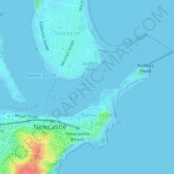
Name: Topografische Karte Newcastle Harbour, Höhe, Relief.
Durchschnittliche Höhe: 5 m
Minimale Höhe: -1 m
Maximale Höhe: 69 m
Andere topografische Karten
Klicken Sie auf eine Karte, um ihre Topografie, ihre Höhe und ihr Relief anzuzeigen.
Civic Park
Australia > New South Wales > Walsh Point
Civic Park, Newcastle, Walsh Point, Newcastle-Maitland, Newcastle City Council, New South Wales, 2300, Australia
Durchschnittliche Höhe: 9 m
Walsh Point
Australia > New South Wales > Walsh Point
Walsh Point, Newcastle-Maitland, Newcastle City Council, New South Wales, 2295, Australia
Durchschnittliche Höhe: 2 m