
Topografische Karte Gasherbrum II
Interaktive Karte
Klicken Sie auf die Karte, um die Höhe anzuzeigen.
Über diese Karte
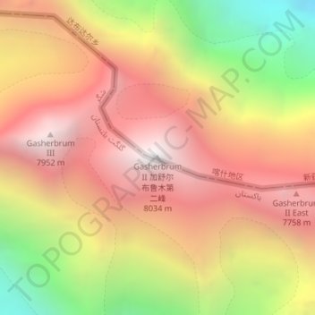
Name: Topografische Karte Gasherbrum II, Höhe, Relief.
Durchschnittliche Höhe: 7.098 m
Minimale Höhe: 5.846 m
Maximale Höhe: 7.992 m
Gasherbrum II is located on the border of Gilgit–Baltistan, Pakistan, and Xinjiang, China. It is part of the Karakoram mountain range in the Himalayas, and located at the top of the Baltoro Glacier. With an elevation of 8,034 metres (26,358 ft) it is the third-highest member of the Gasherbrum group, behind Gasherbrum I (8,080 metres or 26,510 feet) and Broad Peak (8,051 metres or 26,414 feet). Gasherbrum III is sometimes considered to be a subpeak of Gasherbrum II, because the former has a topographic prominence of only 461 metres (1,512 ft).
Andere topografische Karten
Klicken Sie auf eine Karte, um ihre Topografie, ihre Höhe und ihr Relief anzuzeigen.
Broad Peak
China > Xinjiang > Taxkorgan Tajik Autonomous County > Dafdar
Broad Peak, Dafdar, Taxkorgan Tajik Autonomous County, Kashgar Prefecture, Xinjiang, China
Durchschnittliche Höhe: 7.127 m