
Vielen Dank für die Unterstützung dieser Website ❤️
Spenden
Spenden
Topografische Karte Courtallam
Klicken Sie auf die Karte, um die Höhe anzuzeigen.
Vielen Dank für die Unterstützung dieser Website ❤️
Spenden
Spenden
Courtallam
Courtallam is a panchayat town situated at a mean elevation of 160 m (520 ft) in the foothills of the Western Ghats in Tenkasi district of Tamil Nadu, India. The Coutrallam Falls on the Chittar River is a major tourist attraction.
Vielen Dank für die Unterstützung dieser Website ❤️
Spenden
Spenden
Über diese Karte
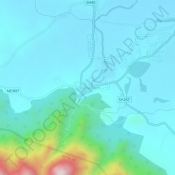
Name: Topografische Karte Courtallam, Höhe, Relief.
Ort: Courtallam, Tenkasi, Tamil Nadu, 627802, India (8.91288 77.25146 8.95288 77.29146)
Durchschnittliche Höhe: 239 m
Minimale Höhe: 152 m
Maximale Höhe: 768 m
Vielen Dank für die Unterstützung dieser Website ❤️
Spenden
Spenden