
Spenden
Topografische Karte Kavaratti
Klicken Sie auf die Karte, um die Höhe anzuzeigen.
Spenden
Kavaratti
The island of Kavaratti lies 360 km (190 nmi) off the coast of the state of Kerala at 10°34′N 72°38′E / 10.57°N 72.64°E / 10.57; 72.64. It has an average elevation of 0 metres (0 feet).
Spenden
Über diese Karte
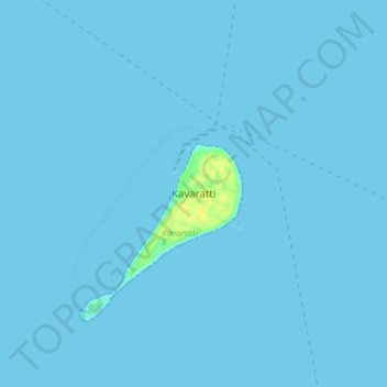
Name: Topografische Karte Kavaratti, Höhe, Relief.
Ort: Kavaratti, Lakshadweep, 262240, India (10.52722 72.59946 10.60722 72.67946)
Durchschnittliche Höhe: 0 m
Minimale Höhe: 0 m
Maximale Höhe: 17 m
Spenden
Andere topografische Karten
Klicken Sie auf eine Karte, um ihre Topografie, ihre Höhe und ihr Relief anzuzeigen.
Kavaratti Island
India > Lakshadweep > Kavaratti > Kavaratti
The island of Kavaratti lies 360 km (190 nmi) off the coast of the state of Kerala at 10°34′N 72°38′E / 10.57°N 72.64°E / 10.57; 72.64. It has an average elevation of 0 metres (0 feet).
Durchschnittliche Höhe: 2 m