
Topografische Karte Ardara
Interaktive Karte
Klicken Sie auf die Karte, um die Höhe anzuzeigen.
Über diese Karte
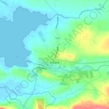
Name: Topografische Karte Ardara, Höhe, Relief.
Ort: Ardara, County Donegal, Ulster, Irlande (54.75792 -8.42623 54.77314 -8.39298)
Durchschnittliche Höhe: 19 m
Minimale Höhe: -1 m
Maximale Höhe: 75 m
Andere topografische Karten
Klicken Sie auf eine Karte, um ihre Topografie, ihre Höhe und ihr Relief anzuzeigen.
Donegal Municipal District
Donegal Municipal District, County Donegal, Ulster, Irlande
Durchschnittliche Höhe: 120 m
Clonmany Civil Parish
Clonmany Civil Parish, County Donegal, Ulster, Irlande
Durchschnittliche Höhe: 92 m
Letterkenny Municipal District
Letterkenny Municipal District, County Donegal, Ulster, Irlande
Durchschnittliche Höhe: 92 m
Glencolumbkille
Glencolumbkille, County Donegal, Irlande
Durchschnittliche Höhe: 95 m
Illion
Illion, Aran ED, Glenties Municipal District, County Donegal, Irlande
Durchschnittliche Höhe: 59 m
Clonmany
Irlande > County Donegal > Clonmany
Clonmany, Inishowen Municipal District, County Donegal, F93 RRX6, Irlande
Durchschnittliche Höhe: 70 m