
Spenden
Topografische Karte Sandness
Klicken Sie auf die Karte, um die Höhe anzuzeigen.
Spenden
Über diese Karte
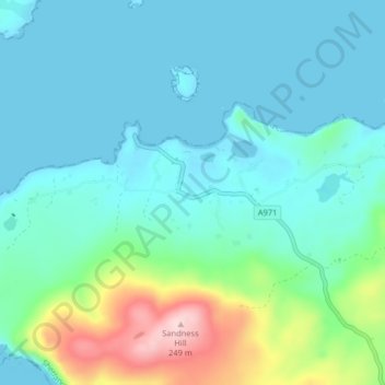
Name: Topografische Karte Sandness, Höhe, Relief.
Ort: Sandness, Shetland, Scotland, ZE2 9PL, United Kingdom (60.27885 -1.67220 60.31885 -1.63220)
Durchschnittliche Höhe: 48 m
Minimale Höhe: -3 m
Maximale Höhe: 247 m
Spenden
Andere topografische Karten
Klicken Sie auf eine Karte, um ihre Topografie, ihre Höhe und ihr Relief anzuzeigen.
Out Skerries
United Kingdom > Scotland > Shetland
Being so close to Norway, the islands were of strategic importance in World War II and were a regular landfall for Norwegian boats carrying escapees from the Nazi occupation. The local coastguard were responsible for the refugees and at one point during the war were issued with a tommy gun, although initially…
Durchschnittliche Höhe: 1 m
Lerwick
United Kingdom > Scotland > Shetland
Lerwick has transitioned from a subpolar oceanic climate (Cfc) to a maritime climate (Cfb) with cool to cold temperatures all year long. The lack of trees reflects the latter type. This is particularly pronounced by virtue of Lerwick being on the coast of an island, so even extreme temperature records are…
Durchschnittliche Höhe: 34 m
Spenden