Geolokalisieren
👉 Easily get elevation data in JSON, GeoTIFF and KML formats using Elevation API
Vielen Dank für die Unterstützung dieser Website ❤️
Spenden

Topografische Karte Ayopaya

Klicken Sie auf die Karte, um die Höhe anzuzeigen.

👉 Easily get elevation data in JSON, GeoTIFF and KML formats using Elevation API
Vielen Dank für die Unterstützung dieser Website ❤️
Spenden

Ayopaya

La provincia de Ayopaya cuenta con una superficie de 9.620 km², de microclimas y topografía variada que va desde los nevados, puna, valles, hasta regiones tropicales, rico en recursos minerales, hidrocarburos y biodiversidad.

Wikipedia (CC-BY-SA 3.0)

👉 Easily get elevation data in JSON, GeoTIFF and KML formats using Elevation API
Vielen Dank für die Unterstützung dieser Website ❤️
Spenden

Über diese Karte

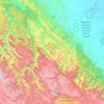
Name: Topografische Karte Ayopaya, Höhe, Relief.

Ort: Ayopaya, Cochabamba, Bolivia (-17.44944 -67.00550 -15.67350 -66.14121)

Durchschnittliche Höhe: 1.928 m

Minimale Höhe: 170 m

Maximale Höhe: 5.739 m

👉 Easily get elevation data in JSON, GeoTIFF and KML formats using Elevation API
Vielen Dank für die Unterstützung dieser Website ❤️
Spenden

Andere topografische Karten

Klicken Sie auf eine Karte, um ihre Topografie, ihre Höhe und ihr Relief anzuzeigen.

Kara Kara

Bolivia > Cochabamba > Capinota > Municipio Sicaya

Durchschnittliche Höhe: 2.786 m

Pocona

Bolivia > Cochabamba > Carrasco > Municipio Pocona

Durchschnittliche Höhe: 2.798 m

Pucarita

Bolivia > Cochabamba > Ayopaya > Municipio Cocapata

Durchschnittliche Höhe: 3.196 m

Plaza Uyuni

Bolivia > Cochabamba > Cercado > Cochabamba

Durchschnittliche Höhe: 2.553 m

Vielen Dank für die Unterstützung dieser Website ❤️
Spenden

Sauce Rancho

Bolivia > Cochabamba > Quillacollo

Durchschnittliche Höhe: 2.569 m

Pucara

Bolivia > Cochabamba > Punata > Municipio Punata

Durchschnittliche Höhe: 2.880 m

Cantumarca

Bolivia > Cochabamba > Ayopaya > Municipio Ayopaya

Durchschnittliche Höhe: 3.009 m

10 de Febrero

Bolivia > Cochabamba > Carrasco > Municipio Entre Ríos

Durchschnittliche Höhe: 228 m

Vielen Dank für die Unterstützung dieser Website ❤️
Spenden

Vinto

Bolivia > Cochabamba > Vinto

Durchschnittliche Höhe: 3.185 m

Vinto

Bolivia > Cochabamba > Arque > Municipio Arque

Durchschnittliche Höhe: 2.871 m

Falsuri

Bolivia > Cochabamba > Quillacollo

Durchschnittliche Höhe: 2.698 m

Cerro Mojona

Bolivia > Cochabamba > Tapacarí > Municipio Tapacarí

Durchschnittliche Höhe: 4.018 m

Vielen Dank für die Unterstützung dieser Website ❤️
Spenden

Cocapata

Bolivia > Cochabamba > Carrasco > Municipio Totora

Durchschnittliche Höhe: 3.006 m

Illataco

Bolivia > Cochabamba > Quillacollo

Durchschnittliche Höhe: 2.596 m

Sauces

Bolivia > Cochabamba > Mizque > Municipio Mizque > Sauces

Durchschnittliche Höhe: 2.046 m

Collpa Cala Cala

Bolivia > Cochabamba > Quillacollo > Collpa Cala Cala

Durchschnittliche Höhe: 4.141 m

Vielen Dank für die Unterstützung dieser Website ❤️
Spenden

Veladeros

Bolivia > Cochabamba > Carrasco > Municipio Totora

Durchschnittliche Höhe: 2.871 m

Eterazama

Bolivia > Cochabamba > Chapare

Durchschnittliche Höhe: 236 m

Trigales

Bolivia > Cochabamba > Campero > Municipio Pasorapa

Durchschnittliche Höhe: 2.371 m

Villa Union

Bolivia > Cochabamba > Municipio Entre Ríos

Durchschnittliche Höhe: 223 m

Vielen Dank für die Unterstützung dieser Website ❤️
Spenden