
Topografische Karte Upheaval Dome
Klicken Sie auf die Karte, um die Höhe anzuzeigen.
Über diese Karte
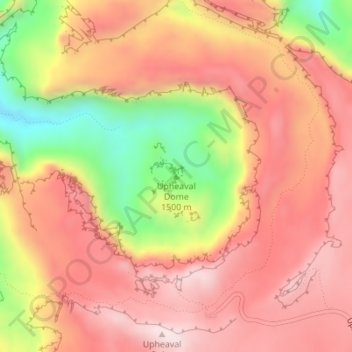
Name: Topografische Karte Upheaval Dome, Höhe, Relief.
Ort: Upheaval Dome, San Juan County, Utah, United States (38.43691 -109.92905 38.43701 -109.92895)
Durchschnittliche Höhe: 1.627 m
Minimale Höhe: 1.331 m
Maximale Höhe: 1.802 m
Andere topografische Karten
Klicken Sie auf eine Karte, um ihre Topografie, ihre Höhe und ihr Relief anzuzeigen.
Montezuma Creek
United States > Utah > San Juan County > Montezuma Creek
Durchschnittliche Höhe: 1.406 m
Monticello
United States > Utah > San Juan County
Monticello is located at the base of the Abajo Mountains, or the Blue Mountains, which are part of the Manti-La Sal National Forest. The elevation of Monticello is 7,069 feet (2,155 m). From Monticello, a tree formation on the Blue Mountains can be seen, which resembles a horse's head and neck, which can be…
Durchschnittliche Höhe: 2.145 m
Natural Bridges National Monument
United States > Utah > San Juan County
Located within the Colorado Plateau, the monument has three distinct bridges in White and Armstrong Canyons. These canyons were formed when the Colorado River eroded the Permian Cedar Mesa Sandstone. The Sipapu, Kachina, and Owachoma bridges were formed through rock decay, weathering and erosion, as water cut…
Durchschnittliche Höhe: 1.916 m
Sentinel Mesa
United States > Utah > San Juan County
Monument Valley is part of the Colorado Plateau. The elevation of the valley floor ranges from 5,000 to 6,000 feet (1,500 to 1,800 m) above sea level. The floor is largely siltstone of the Cutler Group, or sand derived from it, deposited by the meandering rivers that carved the valley. The valley's vivid red…
Durchschnittliche Höhe: 1.683 m
Navajo Mountain
United States > Utah > San Juan County > Navajo Mountain
Durchschnittliche Höhe: 1.806 m
Montezuma Creek
United States > Utah > San Juan County > Montezuma Creek
Durchschnittliche Höhe: 1.406 m