
Spenden
Topografische Karte Harper
Klicken Sie auf die Karte, um die Höhe anzuzeigen.
Spenden
Über diese Karte
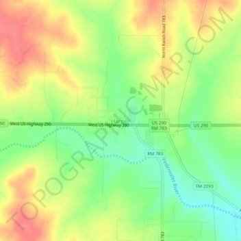
Name: Topografische Karte Harper, Höhe, Relief.
Ort: Harper, Gillespie County, Texas, 78631, United States (30.28073 -99.27084 30.32073 -99.23084)
Durchschnittliche Höhe: 634 m
Minimale Höhe: 599 m
Maximale Höhe: 668 m
Spenden
Andere topografische Karten
Klicken Sie auf eine Karte, um ihre Topografie, ihre Höhe und ihr Relief anzuzeigen.
Fredericksburg
United States > Texas > Gillespie County
Enchanted Rock is a geographical landmark 27 km (17 mi) north of Fredericksburg in Llano County. The rock is a huge, pink granite exfoliation dome that rises 425 ft (130 m) above the surrounding land, has a summit elevation of 1,825 ft (556 m) above sea level, and covers 640 acres (260 ha). Enchanted Rock…
Durchschnittliche Höhe: 526 m
Spenden