
Topografische Karte Highland State Recreation Area
Interaktive Karte
Klicken Sie auf die Karte, um die Höhe anzuzeigen.
Über diese Karte
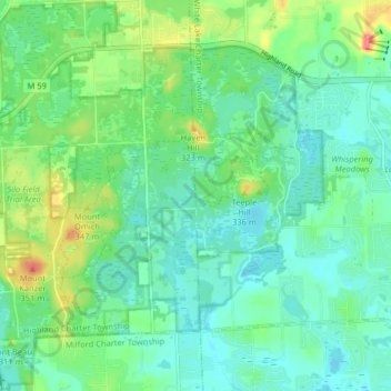
Name: Topografische Karte Highland State Recreation Area, Höhe, Relief.
Durchschnittliche Höhe: 302 m
Minimale Höhe: 282 m
Maximale Höhe: 355 m
West of Duck Lake Road in Highland State Recreation Area, a group of small moraines are locally called "mountains"—the highest elevation in the park, Mount Kanzer, is 1,150 feet (350 m) above sea level. The highland for which this recreation area is named is this group of moraines.