
Topografische Karte Cottondale
Interaktive Karte
Klicken Sie auf die Karte, um die Höhe anzuzeigen.
Über diese Karte
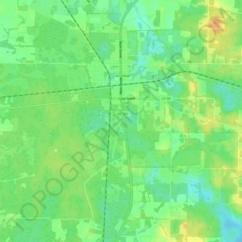
Name: Topografische Karte Cottondale, Höhe, Relief.
Ort: Cottondale, Jackson County, Florida, United States (30.76290 -85.39030 30.81198 -85.33041)
Durchschnittliche Höhe: 45 m
Minimale Höhe: 29 m
Maximale Höhe: 65 m
Andere topografische Karten
Klicken Sie auf eine Karte, um ihre Topografie, ihre Höhe und ihr Relief anzuzeigen.
Greenwood
United States > Florida > Jackson County
Greenwood, Jackson County, Florida, United States
Durchschnittliche Höhe: 39 m
Grand Ridge
United States > Florida > Jackson County
Grand Ridge, Jackson County, Florida, United States
Durchschnittliche Höhe: 43 m
Gulf Islands National Seashore
United States > Florida > Jackson County > Ocean Springs
Gulf Islands National Seashore, Ocean Springs, Jackson County, Florida, 32563, United States
Durchschnittliche Höhe: 20 m
Marianna
United States > Florida > Jackson County
Marianna, Jackson County, Florida, 32447, United States
Durchschnittliche Höhe: 39 m
Haynes
United States > Florida > Jackson County > Haynes
Haynes, Jackson County, Florida, United States
Durchschnittliche Höhe: 28 m
Cypress
United States > Florida > Jackson County > Cypress
Cypress, Jackson County, Florida, 32432, United States
Durchschnittliche Höhe: 41 m