
Topografische Karte Affleck Lake
Interaktive Karte
Klicken Sie auf die Karte, um die Höhe anzuzeigen.
Über diese Karte
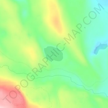
Name: Topografische Karte Affleck Lake, Höhe, Relief.
Durchschnittliche Höhe: 417 m
Minimale Höhe: 337 m
Maximale Höhe: 544 m
Andere topografische Karten
Klicken Sie auf eine Karte, um ihre Topografie, ihre Höhe und ihr Relief anzuzeigen.
Kitwanga
Canada > British Columbia > Regional District of Kitimat-Stikine > Area B (Suskwa/Kitwanga/Kispiox) > Kitwanga
Kitwanga, Area B (Suskwa/Kitwanga/Kispiox), Regional District of Kitimat-Stikine, British Columbia, V0J 2A0, Canada
Durchschnittliche Höhe: 329 m
South Hazelton
Canada > British Columbia > Regional District of Kitimat-Stikine > Area B (Suskwa/Kitwanga/Kispiox) > South Hazelton
South Hazelton, Area B (Suskwa/Kitwanga/Kispiox), Regional District of Kitimat-Stikine, British Columbia, Canada
Durchschnittliche Höhe: 278 m
Kispiox
Canada > British Columbia > Regional District of Kitimat-Stikine > Area B (Suskwa/Kitwanga/Kispiox)
Kispiox, Area B (Suskwa/Kitwanga/Kispiox), Regional District of Kitimat-Stikine, British Columbia, V0J 1Y4, Canada
Durchschnittliche Höhe: 345 m