
Topografische Karte Millau
Interaktive Karte
Klicken Sie auf die Karte, um die Höhe anzuzeigen.
Über diese Karte
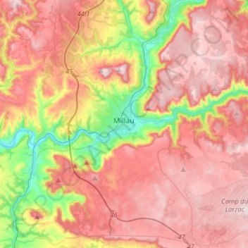
Name: Topografische Karte Millau, Höhe, Relief.
Ort: Millau, Aveyron, Occitania, Metropolitan France, 12100, France (44.01667 2.99064 44.17985 3.24486)
Durchschnittliche Höhe: 656 m
Minimale Höhe: 331 m
Maximale Höhe: 895 m
The territory of this town lies across a southern portion of the Massif Central. It covers a large area of some 16,823 hectares (41,570 acres), which makes it the 25th largest metropolitan town in France. The municipality lies at the heart of the Grands Causses, a part of the Causse Rouge (east of the plateau Lévézou), and part of Larzac as well as part of the Black Causse. The city county seat is located in the lower part of the town, in a large depression at the confluence of the Tarn and Dourbie, at an altitude of about 340 m.
Andere topografische Karten
Klicken Sie auf eine Karte, um ihre Topografie, ihre Höhe und ihr Relief anzuzeigen.
Le Dourdou de Conques
Le Dourdou de Conques, Aveyron, Occitania, Metropolitan France, France
Durchschnittliche Höhe: 576 m
Puech de Montabez
France > Occitania > Aveyron > Florentin-la-Capelle
Puech de Montabez, Florentin-la-Capelle, Rodez, Aveyron, Occitania, Metropolitan France, 12140, France
Durchschnittliche Höhe: 662 m
La Malette
France > Occitania > Aveyron > Entraygues-sur-Truyère
La Malette, Entraygues-sur-Truyère, Rodez, Aveyron, Occitania, Metropolitan France, 12140, France
Durchschnittliche Höhe: 410 m
Novis
France > Occitania > Aveyron > Sévérac d'Aveyron > Sévérac-le-Château
Novis, Sévérac-le-Château, Sévérac d'Aveyron, Rodez, Aveyron, Occitania, Metropolitan France, 12150, France
Durchschnittliche Höhe: 848 m
Saint-Izaire
Saint-Izaire, Millau, Aveyron, Occitania, Metropolitan France, 12480, France
Durchschnittliche Höhe: 383 m
La Graufesenque
France > Occitania > Aveyron > Millau > La Graufesenque
La Graufesenque, Millau, Aveyron, Occitania, Metropolitan France, 12100, France
Durchschnittliche Höhe: 529 m
Palmas
France > Occitania > Aveyron > Palmas d'Aveyron
Palmas, Palmas d'Aveyron, Rodez, Aveyron, Occitania, Metropolitan France, 12310, France
Durchschnittliche Höhe: 613 m
Entraygues-sur-Truyère
Entraygues-sur-Truyère, Rodez, Aveyron, Occitania, Metropolitan France, 12140, France
Durchschnittliche Höhe: 482 m
Salles-la-Source
Salles-la-Source, Rodez, Aveyron, Occitania, Metropolitan France, 12330, France
Durchschnittliche Höhe: 519 m
La Rouquette
La Rouquette, Villefranche-de-Rouergue, Aveyron, Occitania, Metropolitan France, 12200, France
Durchschnittliche Höhe: 340 m
Rieupeyroux
Rieupeyroux, Villefranche-de-Rouergue, Aveyron, Occitania, Metropolitan France, 12240, France
Durchschnittliche Höhe: 613 m