Geolokalisieren
👉 Easily get elevation data in JSON, GeoTIFF and KML formats using Elevation API
Vielen Dank für die Unterstützung dieser Website ❤️
Spenden

Topografische Karte T Dasarahalli

Klicken Sie auf die Karte, um die Höhe anzuzeigen.

👉 Easily get elevation data in JSON, GeoTIFF and KML formats using Elevation API
Vielen Dank für die Unterstützung dieser Website ❤️
Spenden

Über diese Karte

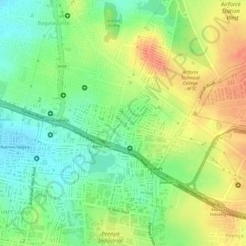
Name: Topografische Karte T Dasarahalli, Höhe, Relief.

Ort: T Dasarahalli, Dasarahalli Zone, Bengaluru, Bangalore North, Bengaluru Urban District, Karnataka, India (13.03994 77.50731 13.05057 77.52220)

Durchschnittliche Höhe: 906 m

Minimale Höhe: 878 m

Maximale Höhe: 935 m

👉 Easily get elevation data in JSON, GeoTIFF and KML formats using Elevation API
Vielen Dank für die Unterstützung dieser Website ❤️
Spenden

Andere topografische Karten

Klicken Sie auf eine Karte, um ihre Topografie, ihre Höhe und ihr Relief anzuzeigen.

Cubbon Park

India > Karnataka > Bangalore North > Bengaluru

Durchschnittliche Höhe: 917 m

Nagarbhavi Lake

India > Karnataka > Bangalore North > Bengaluru

Durchschnittliche Höhe: 853 m

Nagawara Lake

India > Karnataka > Bangalore North > Bengaluru

Durchschnittliche Höhe: 896 m

Banni Mantapa

India > Karnataka > Bangalore North > Bengaluru

Durchschnittliche Höhe: 882 m

Vielen Dank für die Unterstützung dieser Website ❤️
Spenden

Bugle Rock Park

India > Karnataka > Bangalore North > Bengaluru

Durchschnittliche Höhe: 908 m

Bangalore Palace

India > Karnataka > Bangalore North > Bengaluru

Durchschnittliche Höhe: 927 m

Madhavan Park

India > Karnataka > Bangalore North > Bengaluru

Durchschnittliche Höhe: 916 m

Thirumenahalli

India > Karnataka > Bangalore North > Bengaluru > Thirumenahalli

Durchschnittliche Höhe: 908 m

Vielen Dank für die Unterstützung dieser Website ❤️
Spenden

HRBR Layout

India > Karnataka > Bangalore North > Bengaluru

Durchschnittliche Höhe: 895 m

Nagawara Lake

India > Karnataka > Bangalore North > Bengaluru

Durchschnittliche Höhe: 896 m