
Topografische Karte Curlew
Interaktive Karte
Klicken Sie auf die Karte, um die Höhe anzuzeigen.
Über diese Karte
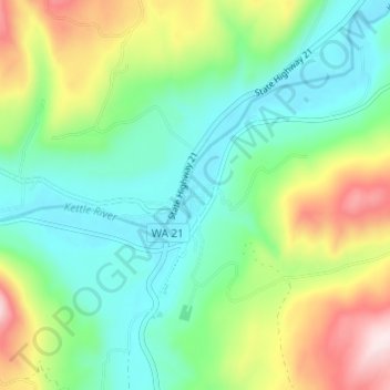
Name: Topografische Karte Curlew, Höhe, Relief.
Ort: Curlew, Ferry County, Washington, United States (48.86545 -118.61947 48.90545 -118.57947)
Durchschnittliche Höhe: 672 m
Minimale Höhe: 533 m
Maximale Höhe: 969 m
Curlew is located at the confluence of Long Alec Creek and the Kettle River. Its elevation is 1,800 feet (550 m) above sea level. Via State Route 21, it is 21 miles (34 km) north of Republic, the Ferry County seat, and 10 miles (16 km) south of the Canadian border.
Andere topografische Karten
Klicken Sie auf eine Karte, um ihre Topografie, ihre Höhe und ihr Relief anzuzeigen.
Keller
United States > Washington > Ferry County
Keller, Ferry County, Washington, 99140, United States
Durchschnittliche Höhe: 536 m
Inchelium
United States > Washington > Ferry County
Inchelium, Ferry County, Washington, United States
Durchschnittliche Höhe: 639 m
Laurier
United States > Washington > Ferry County
Laurier, Ferry County, Washington, 99146, United States
Durchschnittliche Höhe: 604 m
Danville
United States > Washington > Ferry County
Danville, Ferry County, Washington, 99121, United States
Durchschnittliche Höhe: 638 m
Malo
United States > Washington > Ferry County
Malo, Ferry County, Washington, 99160, United States
Durchschnittliche Höhe: 788 m
Orient
United States > Washington > Ferry County
Orient, Ferry County, Washington, United States
Durchschnittliche Höhe: 598 m
Republic
United States > Washington > Ferry County
Republic, Ferry County, Washington, United States
Durchschnittliche Höhe: 826 m
Wiseman Island
United States > Washington > Ferry County > Pollard
Wiseman Island, Pollard, Ferry County, Washington, United States
Durchschnittliche Höhe: 777 m