
Spenden
Topografische Karte Palmas
Klicken Sie auf die Karte, um die Höhe anzuzeigen.
Spenden
Palmas
Palmas is one of the hottest capital cities in Brazil. During the May to September dry season, Palmas can be oppressively hot as temperatures climb into the high 30s (°C). During the October to April rainy season, it is not as hot. The heavy rains and cloud cover keep it much cooler. Palmas receives generous rainfall of about 1,300 mm. It is situated in a 'bow' valley of Rio Tocantins and surrounded by mountains from three sides; with its low elevation, 195 metres above sea level, these factors increase the humidity and discomfort of hot days.
Spenden
Über diese Karte
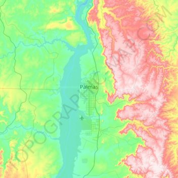
Name: Topografische Karte Palmas, Höhe, Relief.
Durchschnittliche Höhe: 367 m
Minimale Höhe: 189 m
Maximale Höhe: 711 m
Spenden
Andere topografische Karten
Klicken Sie auf eine Karte, um ihre Topografie, ihre Höhe und ihr Relief anzuzeigen.