
Topografische Karte Estes Park
Interaktive Karte
Klicken Sie auf die Karte, um die Höhe anzuzeigen.
Estes Park
Estes Park sits at an elevation of 7,522 feet (2,293 m) on the front range of the Rocky Mountains at the eastern entrance of the Rocky Mountain National Park. Its north, south and east extremities border the Roosevelt National Forest. Lumpy Ridge lies immediately north of Estes Park.
Über diese Karte
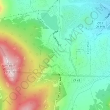
Name: Topografische Karte Estes Park, Höhe, Relief.
Ort: Estes Park, Larimer County, Colorado, United States (40.33115 -105.53675 40.34158 -105.52449)
Durchschnittliche Höhe: 2.543 m
Minimale Höhe: 2.354 m
Maximale Höhe: 2.897 m
Andere topografische Karten
Klicken Sie auf eine Karte, um ihre Topografie, ihre Höhe und ihr Relief anzuzeigen.
Fort Collins
United States > Colorado > Larimer County
Fort Collins is situated at an elevation of approximately 5,003 feet (1,524 meters) above sea level, nestled at the base of the Rocky Mountains in northern Colorado. The city features a varied topography characterized by gently rolling plains that gradually rise to foothills, creating a picturesque backdrop.…
Durchschnittliche Höhe: 1.548 m
Fort Collins
United States > Colorado > Larimer County
Fort Collins is situated at the base of the Rocky Mountain foothills of the northern Front Range, approximately 60 miles (97 km) north of Denver, Colorado, and 45 miles (72 km) south of Cheyenne, Wyoming. Elevation is 4,982 ft (1,519 m) above sea level. Geographic landmarks include Horsetooth Reservoir and…
Durchschnittliche Höhe: 1.548 m
Rocky Mountain National Park
United States > Colorado > Larimer County
Rocky Mountain National Park is one of the highest national parks in the nation, with elevations from 7,860 to 14,259 feet (2,396 to 4,346 m), the highest point of which is Longs Peak. Trail Ridge Road is the highest paved through-road in the country, with a peak elevation of 12,183 feet (3,713 m). Sixty…
Durchschnittliche Höhe: 3.073 m
Cache La Poudre Wilderness
United States > Colorado > Larimer County
The Cache la Poudre Wilderness is federally-protected area administered by the U.S. Forest Service, a division of the U.S. Department of Agriculture. It is located on the Canyon Lakes Ranger District on the Roosevelt National Forest in Colorado. This wilderness covers 9,258 acres (37.47 km2) and is…
Durchschnittliche Höhe: 2.353 m
Fort Collins
United States > Colorado > Larimer County
Fort Collins is situated at the base of the Rocky Mountain foothills of the northern Front Range, approximately 60 miles (97 km) north of Denver, Colorado, and 45 miles (72 km) south of Cheyenne, Wyoming. Elevation is 4,982 ft (1,519 m) above sea level. Geographic landmarks include Horsetooth Reservoir and…
Durchschnittliche Höhe: 1.548 m
Rocky Mountain National Park
United States > Colorado > Larimer County
Rocky Mountain National Park is one of the highest national parks in the nation, with elevations from 7,860 to 14,259 feet (2,396 to 4,346 m), the highest point of which is Longs Peak. Trail Ridge Road is the highest paved through-road in the country, with a peak elevation of 12,183 feet (3,713 m). Sixty…
Durchschnittliche Höhe: 3.073 m
Stanley Heights Subdivision
United States > Colorado > Larimer County > Estes Park
Durchschnittliche Höhe: 2.345 m
Estes Park
United States > Colorado > Larimer County
Estes Park sits at an elevation of 7,522 feet (2,293 m) on the front range of the Rocky Mountains at the eastern entrance of the Rocky Mountain National Park. Its location is 40°22′22″N 105°31′09″W / 40.372856°N 105.519136°W / 40.372856; -105.519136. Its north, south and east extremities…
Durchschnittliche Höhe: 2.421 m
Estes Park
United States > Colorado > Larimer County
Estes Park sits at an elevation of 7,522 feet (2,293 m) on the front range of the Rocky Mountains at the eastern entrance of the Rocky Mountain National Park. Its location is 40°22′22″N 105°31′09″W / 40.372856°N 105.519136°W / 40.372856; -105.519136. Its north, south and east extremities…
Durchschnittliche Höhe: 2.430 m
Estes Park
United States > Colorado > Larimer County > Estes Park > Estes Park
Durchschnittliche Höhe: 2.461 m