
Topografische Karte Elkhorn City
Interaktive Karte
Klicken Sie auf die Karte, um die Höhe anzuzeigen.
Über diese Karte
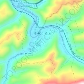
Name: Topografische Karte Elkhorn City, Höhe, Relief.
Ort: Elkhorn City, Pike County, Kentucky, United States (37.28905 -82.36376 37.31256 -82.32504)
Durchschnittliche Höhe: 364 m
Minimale Höhe: 223 m
Maximale Höhe: 657 m
Andere topografische Karten
Klicken Sie auf eine Karte, um ihre Topografie, ihre Höhe und ihr Relief anzuzeigen.
Jonancy
United States > Kentucky > Pike County
Jonancy, Pike County, Kentucky, 41538, United States
Durchschnittliche Höhe: 399 m
McAndrews
United States > Kentucky > Pike County
McAndrews, Pike County, Kentucky, 41567, United States
Durchschnittliche Höhe: 374 m
Pikeville
United States > Kentucky > Pike County
Pikeville, Pike County, Kentucky, 41501, United States
Durchschnittliche Höhe: 338 m
Pleasant Valley
United States > Kentucky > Pike County > Pikeville
Pleasant Valley, Pikeville, Pike County, Kentucky, 41501, United States
Durchschnittliche Höhe: 315 m
Mouthcard
United States > Kentucky > Pike County
Mouthcard, Pike County, Kentucky, 41548, United States
Durchschnittliche Höhe: 393 m
Penny
United States > Kentucky > Pike County
Penny, Pike County, Kentucky, 41560, United States
Durchschnittliche Höhe: 378 m
Toler
United States > Kentucky > Pike County
Toler, Pike County, Kentucky, 25661, United States
Durchschnittliche Höhe: 320 m
Phyllis
United States > Kentucky > Pike County
Phyllis, Pike County, Kentucky, 41554, United States
Durchschnittliche Höhe: 406 m
Pikeville
United States > Kentucky > Pike County > Pikeville > Pikeville
Pikeville, Pike County, Kentucky, 41501, United States
Durchschnittliche Höhe: 312 m
Turkey Creek
United States > Kentucky > Pike County > Turkey Creek
Turkey Creek, Pike County, Kentucky, 41514, United States
Durchschnittliche Höhe: 312 m
Lick Creek
United States > Kentucky > Pike County
Lick Creek, Pike County, Kentucky, 41540, United States
Durchschnittliche Höhe: 430 m