
Spenden
Topografische Karte Orillia
Klicken Sie auf die Karte, um die Höhe anzuzeigen.
Spenden
Über diese Karte
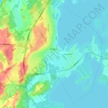
Name: Topografische Karte Orillia, Höhe, Relief.
Ort: Orillia, Central Ontario, Ontario, Canada (44.56717 -79.47570 44.64419 -79.36930)
Durchschnittliche Höhe: 234 m
Minimale Höhe: 215 m
Maximale Höhe: 293 m
Spenden
Andere topografische Karten
Klicken Sie auf eine Karte, um ihre Topografie, ihre Höhe und ihr Relief anzuzeigen.
Toronto
Despite its deep ravines, Toronto is not remarkably hilly, but its elevation does increase steadily away from the lake. Elevation differences range from 76.5 metres (251 ft) above sea level at the Lake Ontario shore to 209 m (686 ft) ASL near the York University grounds in the city's north end at the…
Durchschnittliche Höhe: 113 m
Quadeville
Canada > Ontario > Renfrew County > Brudenell, Lyndoch and Raglan
Durchschnittliche Höhe: 333 m
Niagara Escarpment
Canada > Ontario > Niagara Region > Lincoln > Vineland
Durchschnittliche Höhe: 148 m
Spenden
Ellsmere Island
Canada > Ontario > Parry Sound District > The Archipelago Township
Durchschnittliche Höhe: 197 m
Spenden
St. Helena Island
Canada > Ontario > Leeds and Grenville Counties > Front of Yonge
Durchschnittliche Höhe: 115 m
Slate Islands
Canada > Ontario > Kenora District > Unorganized Kenora District
Durchschnittliche Höhe: 322 m
Spenden
Galbraith Lake
Canada > Ontario > Kenora District > Unorganized Kenora District
Durchschnittliche Höhe: 455 m
Spenden
Morewood
Canada > Ontario > Stormont, Dundas and Glengarry Counties > North Dundas
Durchschnittliche Höhe: 77 m
Sesekinika
Canada > Ontario > Timiskaming District > Unorganized West Timiskaming
Durchschnittliche Höhe: 320 m
Spenden
Ellery Lake
Canada > Ontario > Cochrane District > Unorganized North Cochrane
Durchschnittliche Höhe: 350 m
Manitouwadge
Canada > Ontario > Thunder Bay District > Manitouwadge Township
Durchschnittliche Höhe: 361 m
Spenden
La Cloche Mountains
Canada > Ontario > Sudbury District > Sables-Spanish Rivers Township
Durchschnittliche Höhe: 337 m
Spenden
Opeongo Lake Dam
Canada > Ontario > Nipissing District > Unorganized South Nipissing
Durchschnittliche Höhe: 419 m
Cedar Island
Canada > Ontario > Algoma District > Plummer Additional Township
Durchschnittliche Höhe: 216 m
Spenden
Fauquier
Canada > Ontario > Cochrane District > Fauquier-Strickland Township
Durchschnittliche Höhe: 225 m
Echo Lake
Canada > Ontario > Timiskaming District > Unorganized West Timiskaming
Durchschnittliche Höhe: 339 m
Spenden
Havelock
Canada > Ontario > Peterborough County > Havelock-Belmont-Methuen
Durchschnittliche Höhe: 217 m
Spenden
Pittston
Canada > Ontario > Leeds and Grenville Counties > Edwardsburgh/Cardinal
Durchschnittliche Höhe: 82 m
Spenden
Spenden
Apple Hill
Canada > Ontario > Stormont, Dundas and Glengarry Counties > North Glengarry
Durchschnittliche Höhe: 90 m
Kellow Lake
Canada > Ontario > Thunder Bay District > Unorganized Thunder Bay District
Durchschnittliche Höhe: 294 m
Spenden
Spenden
Loveland Lake
Canada > Ontario > Kenora District > Unorganized Kenora District
Durchschnittliche Höhe: 426 m
Spenden
Berwick
Canada > Ontario > Stormont, Dundas and Glengarry Counties > North Stormont
Durchschnittliche Höhe: 75 m
Spenden
Spenden
Alexandria
Canada > Ontario > Stormont, Dundas and Glengarry Counties > North Glengarry
Durchschnittliche Höhe: 84 m
Spenden
Hubbard Creek
Canada > Ontario > Sudbury District > Unorganized North Sudbury
Durchschnittliche Höhe: 457 m
Searchmont
Canada > Ontario > Algoma District > Unorganized North Algoma
Durchschnittliche Höhe: 285 m
Pancake Bay
Canada > Ontario > Algoma District > Unorganized North Algoma
Durchschnittliche Höhe: 180 m
Spenden
Arbuckle Lake
Canada > Ontario > Haliburton County > Algonquin Highlands
Durchschnittliche Höhe: 444 m
Sly Lake
Canada > Ontario > Cochrane District > Unorganized North Cochrane
Durchschnittliche Höhe: 258 m
Spenden
Spenden
Bala Park Island
Canada > Ontario > Muskoka District > Muskoka Lakes Township > Bala
Durchschnittliche Höhe: 228 m
Spenden
Edison Lake
Canada > Ontario > Kenora District > Unorganized Kenora District
Durchschnittliche Höhe: 385 m
Spenden
Iroquois
Canada > Ontario > Stormont, Dundas and Glengarry Counties > South Dundas
Durchschnittliche Höhe: 83 m
Cockburn Island
Canada > Ontario > Leeds and Grenville Counties > Elizabethtown-Kitley
Durchschnittliche Höhe: 112 m
Spenden
Spenden