
Topografische Karte Taneyville
Interaktive Karte
Klicken Sie auf die Karte, um die Höhe anzuzeigen.
Über diese Karte
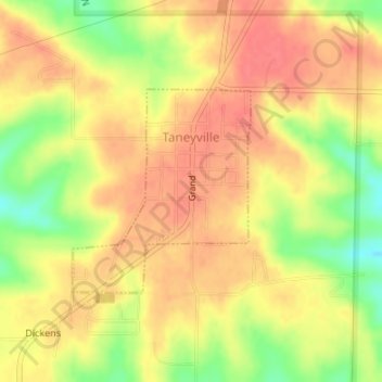
Name: Topografische Karte Taneyville, Höhe, Relief.
Ort: Taneyville, Taney County, Missouri, 65759, United States (36.73039 -93.04480 36.74482 -93.02906)
Durchschnittliche Höhe: 312 m
Minimale Höhe: 273 m
Maximale Höhe: 333 m
Taneyville is located in north-central Taney County. The town lies along Missouri Route 76 between Bradleyville and Kissee Mills. The townsite is on a northeast–southwest trending ridge between Swan Creek to the northwest and Beaver Creek to the southeast. The site is at an elevation of 1,073 ft (327 m).
Andere topografische Karten
Klicken Sie auf eine Karte, um ihre Topografie, ihre Höhe und ihr Relief anzuzeigen.
Branson
United States > Missouri > Taney County
Branson, Taney County, Missouri, United States
Durchschnittliche Höhe: 275 m
Merriam Woods
United States > Missouri > Taney County
Merriam Woods, Taney County, Missouri, 65740, United States
Durchschnittliche Höhe: 287 m
Lake Taneycomo
United States > Missouri > Taney County > Rockaway Beach
Lake Taneycomo, Rockaway Beach, Taney County, Missouri, United States
Durchschnittliche Höhe: 250 m
Kissee Mills
United States > Missouri > Taney County
Kissee Mills, Taney County, Missouri, 65680, United States
Durchschnittliche Höhe: 256 m
Kirbyville
United States > Missouri > Taney County
Kirbyville, Taney County, Missouri, United States
Durchschnittliche Höhe: 301 m
Powersite
United States > Missouri > Taney County > Branson
Powersite, Branson, Taney County, Missouri, 65731, United States
Durchschnittliche Höhe: 257 m
Mincy
United States > Missouri > Taney County
Mincy, Taney County, Missouri, 67679, United States
Durchschnittliche Höhe: 278 m
Protem
United States > Missouri > Taney County
Protem, Taney County, Missouri, 65733, United States
Durchschnittliche Höhe: 244 m
Cedarcreek
United States > Missouri > Taney County
Cedarcreek, Taney County, Missouri, 65627, United States
Durchschnittliche Höhe: 306 m
Kirbyville
United States > Missouri > Taney County
Kirbyville, Taney County, Missouri, United States
Durchschnittliche Höhe: 299 m
Walnut Shade
United States > Missouri > Taney County > Walnut Shade
Walnut Shade, Taney County, Missouri, 65740, United States
Durchschnittliche Höhe: 270 m
Hollister
United States > Missouri > Taney County
Hollister, Taney County, Missouri, United States
Durchschnittliche Höhe: 271 m
Bull Creek
United States > Missouri > Taney County
Bull Creek, Taney County, Missouri, United States
Durchschnittliche Höhe: 256 m
Rockaway Beach
United States > Missouri > Taney County
Rockaway Beach, Taney County, Missouri, United States
Durchschnittliche Höhe: 252 m
Forsyth
United States > Missouri > Taney County
Forsyth, Taney County, Missouri, 65653, United States
Durchschnittliche Höhe: 241 m