
Topografische Karte Abernathy
Interaktive Karte
Klicken Sie auf die Karte, um die Höhe anzuzeigen.
Über diese Karte
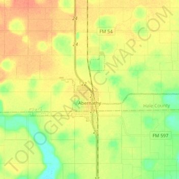
Name: Topografische Karte Abernathy, Höhe, Relief.
Ort: Abernathy, Hale County, Texas, 79311, United States (33.81949 -101.88752 33.86162 -101.75546)
Durchschnittliche Höhe: 1.020 m
Minimale Höhe: 1.000 m
Maximale Höhe: 1.035 m
Abernathy (elevation 3,360 feet) is located at 33°49′56″N 101°50′35″W / 33.83222°N 101.84306°W / 33.83222; -101.84306 (33.8323038, –101.8429491). Most of the city is located in Hale County; roughly 25% of the city extends southward into Lubbock County.
Andere topografische Karten
Klicken Sie auf eine Karte, um ihre Topografie, ihre Höhe und ihr Relief anzuzeigen.
Plainview
United States > Texas > Hale County
Plainview, Hale County, Texas, 79072, United States
Durchschnittliche Höhe: 1.029 m
Lider
United States > Texas > Hale County
Lider, Hale County, Texas, United States
Durchschnittliche Höhe: 1.017 m