
Topografische Karte Highlands
Interaktive Karte
Klicken Sie auf die Karte, um die Höhe anzuzeigen.
Highlands
Highlands was founded in 1875 after its two founders, Samuel Truman Kelsey and Clinton Carter Hutchinson, drew lines from Chicago to Savannah and from New Orleans to New York City. They felt that the place where these lines met would eventually become a great trading center and commercial crossroads. Highlands was named for its lofty elevation.
Über diese Karte
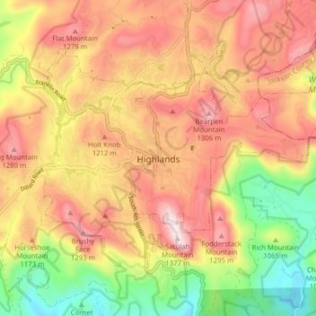
Name: Topografische Karte Highlands, Höhe, Relief.
Durchschnittliche Höhe: 1.116 m
Minimale Höhe: 820 m
Maximale Höhe: 1.360 m
Andere topografische Karten
Klicken Sie auf eine Karte, um ihre Topografie, ihre Höhe und ihr Relief anzuzeigen.