
Topografische Karte Winthrop
Interaktive Karte
Klicken Sie auf die Karte, um die Höhe anzuzeigen.
Über diese Karte
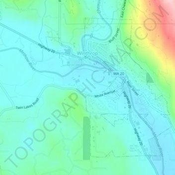
Name: Topografische Karte Winthrop, Höhe, Relief.
Durchschnittliche Höhe: 567 m
Minimale Höhe: 525 m
Maximale Höhe: 736 m
Andere topografische Karten
Klicken Sie auf eine Karte, um ihre Topografie, ihre Höhe und ihr Relief anzuzeigen.
Oroville
United States > Washington > Okanogan County
Oroville, Okanogan County, Washington, 98844, United States
Durchschnittliche Höhe: 351 m
Wauconda
United States > Washington > Okanogan County
Wauconda, Okanogan County, Washington, United States
Durchschnittliche Höhe: 1.183 m
Tonasket
United States > Washington > Okanogan County
Tonasket, Okanogan County, Washington, 98855, United States
Durchschnittliche Höhe: 342 m
Dutton Lakes
United States > Washington > Okanogan County
Dutton Lakes, Okanogan County, Washington, United States
Durchschnittliche Höhe: 2.093 m
Mount Barney
United States > Washington > Okanogan County
Mount Barney, Okanogan County, Washington, United States
Durchschnittliche Höhe: 2.037 m
Rambo
United States > Washington > Okanogan County
Rambo, Okanogan County, Washington, United States
Durchschnittliche Höhe: 2.070 m
Mazama
United States > Washington > Okanogan County
Mazama, Okanogan County, Washington, 98833, United States
Durchschnittliche Höhe: 827 m