
Spenden
Topografische Karte Travis County
Klicken Sie auf die Karte, um die Höhe anzuzeigen.
Spenden
Travis County
Travis County features a varied and dynamic topography characterized by rolling hills, lush valleys, and significant water features. The terrain rises gently from the flatlands in the east to the more rugged and elevated areas in the west, reaching elevations of up to about 1,400 feet above sea level. The county is bisected by the scenic Colorado River, which flows through the area, creating picturesque landscapes and providing recreational opportunities. Notable features include the limestone escarpments and the scenic vistas along the Balcones Fault, which delineates the eastern edge of the Texas Hill Country. This diverse topography supports a mix of ecosystems, including hardwood forests, grassy plains, and areas of dense brush, contributing to the region's natural beauty and outdoor recreational activities.
Spenden
Über diese Karte
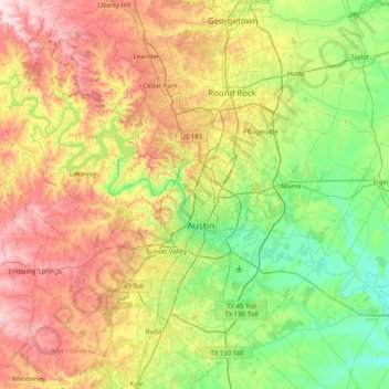
Name: Topografische Karte Travis County, Höhe, Relief.
Ort: Travis County, Texas, United States (30.02333 -98.17314 30.62803 -97.36958)
Durchschnittliche Höhe: 231 m
Minimale Höhe: 102 m
Maximale Höhe: 453 m
Spenden
Andere topografische Karten
Klicken Sie auf eine Karte, um ihre Topografie, ihre Höhe und ihr Relief anzuzeigen.
Georgetown
United States > Texas > Georgetown
The city is located on the northeastern edge of Texas Hill Country. Portions of Georgetown are located on either side of the Balcones Escarpment, a fault line in which the areas roughly east of IH-35 are flat and characterized by having black, fertile soils of the Blackland Prairie, and the west side of the…
Durchschnittliche Höhe: 219 m
Spenden
Spenden
Spenden
Spenden
Spenden
Spenden
Spenden
Spenden
Spenden
Spenden
Enchanted Rock
United States > Texas > Llano County
Enchanted Rock is a pink granite mountain located in the Llano Uplift about 17 miles (27 km) north of Fredericksburg, Texas and 24 miles (39 km) south of Llano, Texas, United States. Enchanted Rock State Natural Area, which includes Enchanted Rock and surrounding land, spans the border between Gillespie and…
Durchschnittliche Höhe: 453 m
Padre Island National Seashore
United States > Texas > Kenedy County > Corpus Christi
Durchschnittliche Höhe: 5 m
Spenden
Spenden
Spenden
Spenden
Spenden
Mission Hills Ranch
United States > Texas > Comal County > New Braunfels
Durchschnittliche Höhe: 287 m
Spenden
Spenden
Spenden
Sundance Square Plaza
United States > Texas > Tarrant County > Fort Worth
Durchschnittliche Höhe: 178 m
Spenden
Spenden
McKinney Falls State Park
United States > Texas > Travis County > Austin
Durchschnittliche Höhe: 171 m
Choke Canyon State Park - Calliham Unit
United States > Texas > McMullen County > Calliham
Durchschnittliche Höhe: 67 m
Spenden
Spenden
Spenden
Mineral Wells Fossil Park
United States > Texas > Palo Pinto County > Mineral Wells
Durchschnittliche Höhe: 283 m
Spenden
Rio Vista Addition Colonia
United States > Texas > El Paso County > Socorro
Durchschnittliche Höhe: 1.116 m
Sierra Blanca
United States > Texas > Hudspeth County
Sierra Blanca is found in Far West Texas, a subdivision of West Texas, and is 4,520 feet (1,380 m) above sea level. The town is part of the Trans-Pecos region within the most mountainous and arid portion of Texas. The town is located in Hudspeth County, which is large and sparsely populated. Sierra Blanca…
Durchschnittliche Höhe: 1.391 m
Spenden