Geolokalisieren
👉 Easily get elevation data in JSON, GeoTIFF and KML formats using Elevation API
Vielen Dank für die Unterstützung dieser Website ❤️
Spenden

Topografische Karte Chikkamagaluru

Klicken Sie auf die Karte, um die Höhe anzuzeigen.

👉 Easily get elevation data in JSON, GeoTIFF and KML formats using Elevation API
Vielen Dank für die Unterstützung dieser Website ❤️
Spenden

Über diese Karte

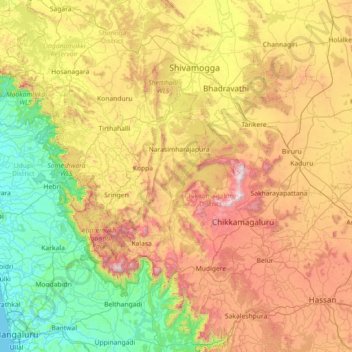
Name: Topografische Karte Chikkamagaluru, Höhe, Relief.

Ort: Chikkamagaluru, Chikkamagaluru District, Karnataka, India (12.80000 74.80000 14.20000 76.20000)

Durchschnittliche Höhe: 628 m

Minimale Höhe: 0 m

Maximale Höhe: 1.879 m

👉 Easily get elevation data in JSON, GeoTIFF and KML formats using Elevation API
Vielen Dank für die Unterstützung dieser Website ❤️
Spenden

Andere topografische Karten

Klicken Sie auf eine Karte, um ihre Topografie, ihre Höhe und ihr Relief anzuzeigen.

Bengaluru

India > Karnataka > Bangalore North

Bengaluru (formerly Bangalore) is situated in the southeastern part of Karnataka, India, within the Bengaluru Urban district. It lies at an elevation of approximately 900 meters (3,000 feet) above sea level, on the Deccan Plateau. This elevated position gives the city a moderate climate, with temperatures…

Durchschnittliche Höhe: 881 m

Koppal

India > Karnataka

Durchschnittliche Höhe: 531 m

Bangalore Urban

India > Karnataka

Durchschnittliche Höhe: 856 m

Vielen Dank für die Unterstützung dieser Website ❤️
Spenden

Karwar taluk

India > Karnataka

Durchschnittliche Höhe: 236 m

BTM

India > Karnataka > Bengaluru

Durchschnittliche Höhe: 899 m

Bannerghatta National Park

India > Karnataka > Harohalli taluk > Gullahatti Kaval

The 65,127.5 acre (260.51 km2) national park is located about 22 km south of Bangalore in the hills of the Anekal range with an elevation of 1245 - 1634m. The park has a hilly terrain of granite sheets under moist deciduous forest valleys and scrubland on higher areas. Sixteen villages border the park. Most of…

Durchschnittliche Höhe: 782 m

Chikkaballapura

India > Karnataka

Durchschnittliche Höhe: 783 m

Vielen Dank für die Unterstützung dieser Website ❤️
Spenden

Vijayapura

India > Karnataka

Durchschnittliche Höhe: 524 m

Anekal

India > Karnataka

Durchschnittliche Höhe: 888 m

Davanagere

India > Karnataka

Durchschnittliche Höhe: 650 m

Bangalore East

India > Karnataka

Durchschnittliche Höhe: 889 m

Vielen Dank für die Unterstützung dieser Website ❤️
Spenden

Chikkamagaluru taluku

India > Karnataka

Durchschnittliche Höhe: 946 m

Devanahalli taluku

India > Karnataka

Durchschnittliche Höhe: 907 m

Hassan

India > Karnataka

Durchschnittliche Höhe: 892 m

Bidar

India > Karnataka

Physiographically, the district can be divided into two regions, the northern low lands and southern high lands. The southern high lands are popularly known as Bidar plateau, which is made up of laterite. The ground altitudes are varying from 420 to 684 m (1,378 to 2,244 ft) above sea level. Bidar plateau has…

Durchschnittliche Höhe: 576 m

Vielen Dank für die Unterstützung dieser Website ❤️
Spenden

Belagavi

India > Karnataka

Durchschnittliche Höhe: 613 m

Kolar

India > Karnataka

Durchschnittliche Höhe: 796 m

Hukkeri taluk

India > Karnataka

Durchschnittliche Höhe: 689 m

Devanahalli taluk

India > Karnataka

Durchschnittliche Höhe: 907 m

Vielen Dank für die Unterstützung dieser Website ❤️
Spenden

Pushpagiri WLS

India > Karnataka

Durchschnittliche Höhe: 720 m

Mudigere taluk

India > Karnataka

Durchschnittliche Höhe: 802 m

Bengaluru Rural District

India > Karnataka

Durchschnittliche Höhe: 851 m

Ranebennuru taluk

India > Karnataka

Durchschnittliche Höhe: 571 m

Vielen Dank für die Unterstützung dieser Website ❤️
Spenden

Dakshina Kannada

India > Karnataka

The topography of the district is plain up to 30 km (18.64 mi) inside the coast and changes to undulating hilly terrain sharply towards the east in the Western Ghats. Teak, bamboo and rosewood trees are found in the hilly areas towards the east. The Geological Survey of India has identified this district as a…

Durchschnittliche Höhe: 109 m

Haveri

India > Karnataka

Durchschnittliche Höhe: 584 m

Bangalore South

India > Karnataka

Durchschnittliche Höhe: 846 m

Uttara Kannada

India > Karnataka

The district's high rainfall supports lush forests, which cover approximately 70% of the district. The Malabar Coast moist forests ecoregion lies in a narrow strip between the Arabian Sea and the foothills of the Western Ghats up to 250 meters elevation. These forests have been almost completely converted to…

Durchschnittliche Höhe: 364 m

Vielen Dank für die Unterstützung dieser Website ❤️
Spenden

Raichur

India > Karnataka

Durchschnittliche Höhe: 430 m

Sira taluk

India > Karnataka

Durchschnittliche Höhe: 688 m

Madikeri taluku

India > Karnataka

Durchschnittliche Höhe: 677 m

Bangalore North

India > Karnataka

Durchschnittliche Höhe: 870 m

Vielen Dank für die Unterstützung dieser Website ❤️
Spenden

Malaprabha

India > Karnataka

The Malaprabha River (Kannada ಮಲಪ್ರಭಾ ನದಿ) is a tributary of the Krishna River and flows through the state of Karnataka in India.[citation needed] It rises in the Western Ghats at an elevation of 792.4 m (2,600 ft) in the state's Belgaum district. The river joins Krishna River at…

Durchschnittliche Höhe: 608 m

Gadag

India > Karnataka

Durchschnittliche Höhe: 597 m

Vijayanagara

India > Karnataka

Durchschnittliche Höhe: 587 m

Srirangapattana taluk

India > Karnataka

Durchschnittliche Höhe: 731 m

Vielen Dank für die Unterstützung dieser Website ❤️
Spenden

Tumkur district

India > Karnataka

Durchschnittliche Höhe: 755 m

Somawarpet taluk

India > Karnataka

Durchschnittliche Höhe: 869 m

Ramanagara taluk

India > Karnataka

Durchschnittliche Höhe: 734 m

Shimoga

India > Karnataka

Durchschnittliche Höhe: 557 m

Vielen Dank für die Unterstützung dieser Website ❤️
Spenden

Virajpet taluk

India > Karnataka

Durchschnittliche Höhe: 841 m

Kanakapura taluk

India > Karnataka

Durchschnittliche Höhe: 700 m

Bellary taluk

India > Karnataka

Durchschnittliche Höhe: 448 m

Yelahanka taluku

India > Karnataka

Durchschnittliche Höhe: 898 m

Vielen Dank für die Unterstützung dieser Website ❤️
Spenden

Shorapur

India > Karnataka

Durchschnittliche Höhe: 422 m

Nagamangala taluk

India > Karnataka

Durchschnittliche Höhe: 817 m

Bagalakote taluk

India > Karnataka

Durchschnittliche Höhe: 559 m

Shivamogga taluk

India > Karnataka

Durchschnittliche Höhe: 644 m

Vielen Dank für die Unterstützung dieser Website ❤️
Spenden

Chikkamagaluru

India > Karnataka

Durchschnittliche Höhe: 714 m

Kollegala taluk

India > Karnataka

Durchschnittliche Höhe: 683 m

Pavagada taluk

India > Karnataka

Durchschnittliche Höhe: 632 m

Kalaburagi

India > Karnataka

Kalaburagi is situated in Deccan Plateau located at 17°20′N 76°50′E / 17.33°N 76.83°E / 17.33; 76.83 and the general elevation ranges from 300 to 750 meters above mean sea level. The main river is the Bhima.

Durchschnittliche Höhe: 497 m

Vielen Dank für die Unterstützung dieser Website ❤️
Spenden

Ramanagara

India > Karnataka

Ramanagara is approximately 50 km southwest of Bangalore. The district shares borders with the districts of Bangalore Urban in the east, Bangalore Rural in the North-east, Tumakuru in the North-west, Mandya in the west and Chamarajanagara in the south-west and Krishnagiri district of Tamilnadu state in the…

Durchschnittliche Höhe: 764 m

Dharwad

India > Karnataka

Durchschnittliche Höhe: 613 m

Udupi

India > Karnataka

Durchschnittliche Höhe: 267 m

Mandya

India > Karnataka

Durchschnittliche Höhe: 768 m

Vielen Dank für die Unterstützung dieser Website ❤️
Spenden

Harohalli taluk

India > Karnataka

Durchschnittliche Höhe: 771 m

Ballari

India > Karnataka

Durchschnittliche Höhe: 475 m

Ghataprabha

India > Karnataka

The source of the river can be identified from Phatakwadi Lake 15°56′22″N 74°03′34″E / 15.939335°N 74.059535°E / 15.939335; 74.059535, at an elevation of 750 metres above mean sea level.

Durchschnittliche Höhe: 605 m

Chitradurga

India > Karnataka

Durchschnittliche Höhe: 635 m

Vielen Dank für die Unterstützung dieser Website ❤️
Spenden

Shirasi Taluk

India > Karnataka

Durchschnittliche Höhe: 508 m

Kabini

India > Karnataka

Durchschnittliche Höhe: 794 m

Mudalagi taluku

India > Karnataka

Durchschnittliche Höhe: 590 m

Vielen Dank für die Unterstützung dieser Website ❤️
Spenden

Bangalore East

India > Karnataka

Durchschnittliche Höhe: 889 m

Shikaripalya Lake

India > Karnataka > Anekal

Durchschnittliche Höhe: 927 m

Sahakarnagar C Block Park

India > Karnataka > Yelahanka taluku > Bengaluru

Durchschnittliche Höhe: 913 m

Shivaji Nagar Ward

India > Karnataka > Bangalore North > Bengaluru

Durchschnittliche Höhe: 916 m

Vielen Dank für die Unterstützung dieser Website ❤️
Spenden

Manipal Lake

India > Karnataka > Udupi taluku > Manipal

Durchschnittliche Höhe: 63 m

Kengeri

India > Karnataka > Bengaluru

Durchschnittliche Höhe: 803 m

Ulsoor Lake

India > Karnataka > Bangalore North > Bengaluru

Durchschnittliche Höhe: 905 m

Veerasandra Lake

India > Karnataka > Anekal

Durchschnittliche Höhe: 918 m

Vielen Dank für die Unterstützung dieser Website ❤️
Spenden

Padmanabhanagar Park

India > Karnataka > Bangalore South

Durchschnittliche Höhe: 888 m

Begur

India > Karnataka > Bangalore South > Bengaluru

Durchschnittliche Höhe: 916 m

Bellandur Lake

India > Karnataka > Bangalore South

Durchschnittliche Höhe: 880 m

Jayanagar East Ward

India > Karnataka > Bengaluru

Durchschnittliche Höhe: 910 m

Vielen Dank für die Unterstützung dieser Website ❤️
Spenden

Ittangur Lake

India > Karnataka > Anekal > V Kallahalli > Ittangur

Durchschnittliche Höhe: 880 m

Yamare

India > Karnataka > Anekal > Yamare

Durchschnittliche Höhe: 890 m

560100

India > Karnataka > Bangalore South > Electronic City

Durchschnittliche Höhe: 925 m

Raghuvanahalli

India > Karnataka > Bangalore East

Durchschnittliche Höhe: 867 m

Vielen Dank für die Unterstützung dieser Website ❤️
Spenden

Kodigehalli

India > Karnataka > Bangalore North > Bengaluru

Durchschnittliche Höhe: 904 m

Jakkur Lake

India > Karnataka > Yelahanka taluku > Bengaluru

Durchschnittliche Höhe: 900 m

Mysore Palace

India > Karnataka > Mysuru taluk > Mysuru

Durchschnittliche Höhe: 747 m

Koni

India > Karnataka > Kundapura

Durchschnittliche Höhe: 12 m

Vielen Dank für die Unterstützung dieser Website ❤️
Spenden

Nagarbhavi Lake

India > Karnataka > Bangalore North > Bengaluru

Durchschnittliche Höhe: 853 m

Marasandra

India > Karnataka > Yelahanka taluku

Durchschnittliche Höhe: 908 m

Horamavu

India > Karnataka > Bengaluru

Durchschnittliche Höhe: 894 m

Jakkuru

India > Karnataka > Yelahanka taluku > Gastikempanahalli

Durchschnittliche Höhe: 903 m

Vielen Dank für die Unterstützung dieser Website ❤️
Spenden

Rajarajeshwari Nagar

India > Karnataka > Bangalore South > Bengaluru

Durchschnittliche Höhe: 828 m

Nagarbhavi Thorai

India > Karnataka > Bengaluru

Durchschnittliche Höhe: 840 m

Kundalahalli Lake

India > Karnataka > Bengaluru

Durchschnittliche Höhe: 890 m

Yelahanka Lake

India > Karnataka > Yelahanka taluku > Bengaluru

Durchschnittliche Höhe: 904 m

Vielen Dank für die Unterstützung dieser Website ❤️
Spenden

Cubbon Park

India > Karnataka > Bangalore North > Bengaluru

Durchschnittliche Höhe: 917 m

Avalahalli

India > Karnataka > Bangalore East

Durchschnittliche Höhe: 875 m

Rajarajeshwari Nagar Zone

India > Karnataka > Bangalore North > Bengaluru

Durchschnittliche Höhe: 857 m

Peenya Industrial Area

India > Karnataka > Bengaluru

Durchschnittliche Höhe: 907 m

Vielen Dank für die Unterstützung dieser Website ❤️
Spenden

Kalkere Lake

India > Karnataka > Bengaluru

Durchschnittliche Höhe: 885 m

Hoodi Lake

India > Karnataka > Bangalore East > Sadaramangala

Durchschnittliche Höhe: 889 m

Nagawara Lake

India > Karnataka > Bangalore North > Bengaluru

Durchschnittliche Höhe: 896 m

Gunjur Palya Lake

India > Karnataka > Bangalore East > Kachamaranahalli

Durchschnittliche Höhe: 885 m

Vielen Dank für die Unterstützung dieser Website ❤️
Spenden