Geolokalisieren
👉 Easily get elevation data in JSON, GeoTIFF and KML formats using Elevation API
Vielen Dank für die Unterstützung dieser Website ❤️
Spenden

Topografische Karte Villalba

Klicken Sie auf die Karte, um die Höhe anzuzeigen.

👉 Easily get elevation data in JSON, GeoTIFF and KML formats using Elevation API
Vielen Dank für die Unterstützung dieser Website ❤️
Spenden

Villalba

El relieve es predominantemente llano, característico de la comarca a la que pertenece. La serra da Cabra y el río Eume hacen de límite natural por el norte con Muras. En esta sierra es donde se alcanzan las máximas altitudes, destacando Coto de Monseibán (935 metros) y A Carba (907 metros). Algunos ríos discurren por el territorio, la mayoría procedentes de las sierras situadas más al oeste, destacando el río Trimaz, el río Ladra y el río Labrada.

Wikipedia (CC-BY-SA 3.0)

👉 Easily get elevation data in JSON, GeoTIFF and KML formats using Elevation API
Vielen Dank für die Unterstützung dieser Website ❤️
Spenden

Über diese Karte

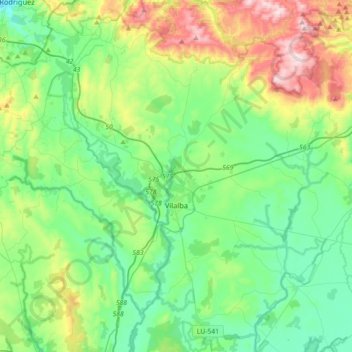
Name: Topografische Karte Villalba, Höhe, Relief.

Ort: Villalba, Tierra Chá, Lugo, Galicia, España (43.18767 -7.83176 43.44779 -7.51555)

Durchschnittliche Höhe: 509 m

Minimale Höhe: 341 m

Maximale Höhe: 961 m

👉 Easily get elevation data in JSON, GeoTIFF and KML formats using Elevation API
Vielen Dank für die Unterstützung dieser Website ❤️
Spenden

Andere topografische Karten

Klicken Sie auf eine Karte, um ihre Topografie, ihre Höhe und ihr Relief anzuzeigen.

Altos do Fiouco

España > Galicia > Tierra Chá > Abadín

Durchschnittliche Höhe: 794 m

Vilalba

España > Galicia > Tierra Chá > Vilalba > Vilalba

Durchschnittliche Höhe: 466 m

Framil

España > Galicia > Tierra Chá > Xermade

Durchschnittliche Höhe: 474 m

Abelaira

España > Galicia > Tierra Chá > Muras

Durchschnittliche Höhe: 801 m

Vielen Dank für die Unterstützung dieser Website ❤️
Spenden

Gañidoira

España > Galicia > Tierra Chá > Muras

Durchschnittliche Höhe: 679 m

O Cordal

España > Galicia > Tierra Chá > Villalba

Durchschnittliche Höhe: 466 m

A Xesta

España > Galicia > Tierra Chá > Abadín

Durchschnittliche Höhe: 555 m

Sistallo

España > Galicia > Tierra Chá

Durchschnittliche Höhe: 424 m

Vielen Dank für die Unterstützung dieser Website ❤️
Spenden

Estremil

España > Galicia > Tierra Chá > Guitiriz

Durchschnittliche Höhe: 591 m

Ubeda

España > Galicia > Tierra Chá > A Pastoriza > Ubeda

Durchschnittliche Höhe: 548 m

O Someiro

España > Galicia > Tierra Chá > Abadín

Durchschnittliche Höhe: 560 m

O Cal

España > Galicia > Tierra Chá > Abadín

Durchschnittliche Höhe: 568 m

Vielen Dank für die Unterstützung dieser Website ❤️
Spenden

Sarela

España > Galicia > Tierra Chá > Villalba

Durchschnittliche Höhe: 552 m

Alto de Roca

España > Galicia > Tierra Chá > Guitiriz

Durchschnittliche Höhe: 475 m

A Bouza

España > Galicia > Tierra Chá > A Feira do Monte

Durchschnittliche Höhe: 408 m

Castro de Ribeiras de Lea

España > Galicia > Tierra Chá

Durchschnittliche Höhe: 407 m

Vielen Dank für die Unterstützung dieser Website ❤️
Spenden

Portopulgo

España > Galicia > Tierra Chá > Guitiriz

Durchschnittliche Höhe: 451 m

Os Campos

España > Galicia > Tierra Chá > Castro de Rei

Durchschnittliche Höhe: 405 m

Cece

España > Galicia > Tierra Chá > Guitiriz

Durchschnittliche Höhe: 529 m

Santalla de Pena

España > Galicia > Tierra Chá > Begonte

Durchschnittliche Höhe: 529 m

Vielen Dank für die Unterstützung dieser Website ❤️
Spenden

A Silvosa

España > Galicia > Tierra Chá > Castro de Rei

Durchschnittliche Höhe: 405 m

Outeiro

España > Galicia > Tierra Chá > Castro de Rei

Durchschnittliche Höhe: 425 m

Pousadela

España > Galicia > Tierra Chá > Castro de Rei > Pousadela

Durchschnittliche Höhe: 492 m

A Pastoriza

España > Galicia > Tierra Chá > A Pastoriza > A Pastoriza

Durchschnittliche Höhe: 509 m

Vielen Dank für die Unterstützung dieser Website ❤️
Spenden

Begonte

España > Galicia > Tierra Chá > Begonte > Begonte

Durchschnittliche Höhe: 429 m

Bouzaboa

España > Galicia > Tierra Chá > Castro de Rei > Bouzaboa

Durchschnittliche Höhe: 418 m

Belesar

España > Galicia > Tierra Chá > Vilalba

Durchschnittliche Höhe: 471 m

A Reigada

España > Galicia > Tierra Chá > Castro de Rei

Durchschnittliche Höhe: 434 m

Vielen Dank für die Unterstützung dieser Website ❤️
Spenden

A Tiñaz

España > Galicia > Tierra Chá > Guitiriz

Durchschnittliche Höhe: 514 m

Esportel

España > Galicia > Tierra Chá > Begonte

Durchschnittliche Höhe: 437 m

Saa

España > Galicia > Tierra Chá > Guitiriz

Durchschnittliche Höhe: 445 m