
Spenden
Topografische Karte Stalham
Klicken Sie auf die Karte, um die Höhe anzuzeigen.
Spenden
Über diese Karte
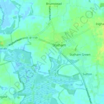
Name: Topografische Karte Stalham, Höhe, Relief.
Ort: Stalham, North Norfolk, Norfolk, England, United Kingdom (52.75594 1.47443 52.78244 1.53973)
Durchschnittliche Höhe: 4 m
Minimale Höhe: -3 m
Maximale Höhe: 14 m
Spenden
Andere topografische Karten
Klicken Sie auf eine Karte, um ihre Topografie, ihre Höhe und ihr Relief anzuzeigen.
Town Hill
United Kingdom > England > Norfolk > North Norfolk > West Runton
Durchschnittliche Höhe: 50 m
Beacon Hill
United Kingdom > England > Norfolk > North Norfolk
Beacon Hill is a part of the Cromer Ridge which is a ridge of old glacial moraines (terminal moraine) that stands next to the coast above Cromer. The Cromer Ridge seems to have been the front line of the ice sheet for some time at the last glaciations, which is shown by the large size of the feature. All the…
Durchschnittliche Höhe: 65 m
Spenden
Stalham Green
United Kingdom > England > Norfolk > North Norfolk > Stalham Green
Durchschnittliche Höhe: 5 m
Johnson Street
United Kingdom > England > Norfolk > North Norfolk > Ludham > Johnson Street
Durchschnittliche Höhe: 3 m
Pollard Street
United Kingdom > England > Norfolk > North Norfolk > Bacton
Durchschnittliche Höhe: 15 m
Spenden
Calthorpe Street
United Kingdom > England > Norfolk > North Norfolk > Ingham
Durchschnittliche Höhe: 3 m
The Eye
United Kingdom > England > Norfolk > North Norfolk > Cley next the Sea
Durchschnittliche Höhe: 2 m
Spenden
North Walsham and Dilham Canal
United Kingdom > England > Norfolk > North Norfolk > Honing
Durchschnittliche Höhe: 21 m
Spenden
Ridlington
United Kingdom > England > Norfolk > North Norfolk > Witton and Ridlington
Durchschnittliche Höhe: 9 m
Spenden
The Lowlands
United Kingdom > England > Norfolk > North Norfolk > Calthorpe
Durchschnittliche Höhe: 28 m
Whimpwell Green
United Kingdom > England > Norfolk > North Norfolk > Happisburgh
Durchschnittliche Höhe: 4 m
Crowgate Street
United Kingdom > England > Norfolk > North Norfolk > Tunstead
Durchschnittliche Höhe: 14 m
Spenden
Beeston Bump
United Kingdom > England > Norfolk > North Norfolk > Sheringham > Beeston Regis
Durchschnittliche Höhe: 20 m
Banningham
United Kingdom > England > Norfolk > North Norfolk > Banningham
Durchschnittliche Höhe: 22 m
Newgate
United Kingdom > England > Norfolk > North Norfolk > Cley next the Sea > Newgate
Durchschnittliche Höhe: 22 m
Spenden
Bacton Green
United Kingdom > England > Norfolk > North Norfolk > Bacton > Bacton Green
Durchschnittliche Höhe: 9 m
West Raynham
United Kingdom > England > Norfolk > North Norfolk > West Raynham
Durchschnittliche Höhe: 59 m
Sheringham Park
United Kingdom > England > Norfolk > North Norfolk > Upper Sheringham
Durchschnittliche Höhe: 61 m
Spenden
Little London
United Kingdom > England > Norfolk > North Norfolk > Corpusty
Durchschnittliche Höhe: 44 m