
Spenden
Topografische Karte Bandipalya
Klicken Sie auf die Karte, um die Höhe anzuzeigen.
Spenden
Über diese Karte
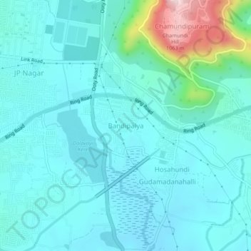
Name: Topografische Karte Bandipalya, Höhe, Relief.
Ort: Bandipalya, Mysuru taluk, Mysuru, Karnataka, 570004, India (12.23710 76.64234 12.27710 76.68234)
Durchschnittliche Höhe: 745 m
Minimale Höhe: 689 m
Maximale Höhe: 1.047 m
Spenden
Andere topografische Karten
Klicken Sie auf eine Karte, um ihre Topografie, ihre Höhe und ihr Relief anzuzeigen.
Mysuru
India > Karnataka > Mysuru taluk > Mysuru
Mysore is situated at the foothills of the Chamundi Hills. At an altitude of 770 m (2,530 ft) above mean sea level, the city of Mysore is geographically located at 12° 18′ 26″ north latitude and 76° 38′ 59″ east longitude. It is about 140 km (87.0 mi) southwest of the state's capital, Bangalore, and…
Durchschnittliche Höhe: 752 m