
Vielen Dank für die Unterstützung dieser Website ❤️
Spenden
Spenden
Topografische Karte Montalban
Klicken Sie auf die Karte, um die Höhe anzuzeigen.
Vielen Dank für die Unterstützung dieser Website ❤️
Spenden
Spenden
Montalban
Rodriguez is generally very rough in topography, with 83% of its total land area composed of upland areas, hills and mountain ranges. The remaining 17% low-lying terrain and rolling lands are found at the south-western portion of the municipality, along with the northern portions of the Municipality of San Mateo.
Vielen Dank für die Unterstützung dieser Website ❤️
Spenden
Spenden
Über diese Karte
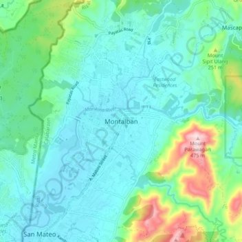
Name: Topografische Karte Montalban, Höhe, Relief.
Ort: Montalban, Rizal, Calabarzon, 1860, Philippines (14.69247 121.10527 14.77247 121.18527)
Durchschnittliche Höhe: 99 m
Minimale Höhe: 8 m
Maximale Höhe: 459 m
Vielen Dank für die Unterstützung dieser Website ❤️
Spenden
Spenden