
Spenden
Topografische Karte Fareham
Klicken Sie auf die Karte, um die Höhe anzuzeigen.
Spenden
Über diese Karte
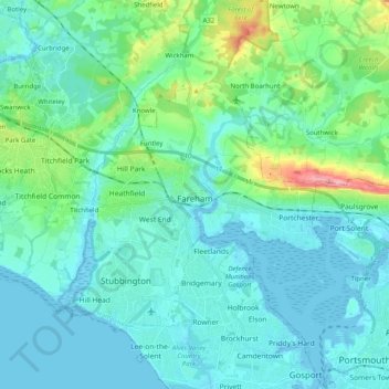
Name: Topografische Karte Fareham, Höhe, Relief.
Ort: Fareham, Hampshire, England, United Kingdom (50.80894 -1.31291 50.89901 -1.11229)
Durchschnittliche Höhe: 21 m
Minimale Höhe: -4 m
Maximale Höhe: 128 m
Spenden
Andere topografische Karten
Klicken Sie auf eine Karte, um ihre Topografie, ihre Höhe und ihr Relief anzuzeigen.
Cocksford Firs East
United Kingdom > England > Hampshire > Basingstoke and Deane > Steventon
Durchschnittliche Höhe: 153 m
Spenden
Farnborough
United Kingdom > England > Hampshire > Rushmoor
Farnborough is located in the northeastern corner of the county of Hampshire, near the border with Surrey. The town occupies a valley setting, with the main urban area situated between the River Blackwater to the east and higher ground to the west. The topography gradually rises from the valley floor, reaching…
Durchschnittliche Höhe: 82 m
Spenden
Woolton Hill
United Kingdom > England > Hampshire > Basingstoke and Deane
Durchschnittliche Höhe: 126 m
Islands
United Kingdom > England > Hampshire > Test Valley > West Tytherley
Durchschnittliche Höhe: 65 m
Spenden
Sherborne St John
United Kingdom > England > Hampshire > Basingstoke and Deane
Durchschnittliche Höhe: 92 m
Spenden