
Topografische Karte Hermosillo
Interaktive Karte
Klicken Sie auf die Karte, um die Höhe anzuzeigen.
Über diese Karte
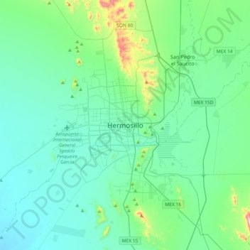
Name: Topografische Karte Hermosillo, Höhe, Relief.
Ort: Hermosillo, Sonora, 83140, Mexico (28.93483 -111.12922 29.25483 -110.80922)
Durchschnittliche Höhe: 248 m
Minimale Höhe: 137 m
Maximale Höhe: 875 m
The Cerro de la Campana mountain is one of the symbols of Hermosillo. Its summit is 350 metres (1,150 ft) above the valley floor and contains a lookout called El Caracol, which was inaugurated in 1909. There are two theories as to the origin of the mountain's name. One states that it is from a peculiar metallic sound that is made when the mountain's rocks fall against each other. The other is based on the bell-like shape of the elevation.