Geolokalisieren
👉 Easily get elevation data in JSON, GeoTIFF and KML formats using Elevation API
Vielen Dank für die Unterstützung dieser Website ❤️
Spenden

Topografische Karte Santa Pau

Klicken Sie auf die Karte, um die Höhe anzuzeigen.

👉 Easily get elevation data in JSON, GeoTIFF and KML formats using Elevation API
Vielen Dank für die Unterstützung dieser Website ❤️
Spenden

Über diese Karte

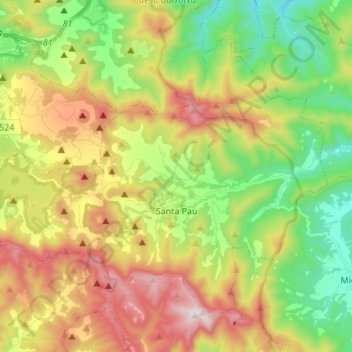
Name: Topografische Karte Santa Pau, Höhe, Relief.

Ort: Santa Pau, Garrotxa, Girona, Catalonia, 17811, Spain (42.11366 2.49372 42.19442 2.62966)

Durchschnittliche Höhe: 545 m

Minimale Höhe: 213 m

Maximale Höhe: 1.004 m

👉 Easily get elevation data in JSON, GeoTIFF and KML formats using Elevation API
Vielen Dank für die Unterstützung dieser Website ❤️
Spenden

Andere topografische Karten

Klicken Sie auf eine Karte, um ihre Topografie, ihre Höhe und ihr Relief anzuzeigen.

Pallerols

Spain > Catalonia > Garrotxa > Sant Feliu de Pallerols

Durchschnittliche Höhe: 608 m

Sant Esteve d'en Bas

Spain > Catalonia > Garrotxa > la Vall d'en Bas

Durchschnittliche Höhe: 560 m

Olot

Spain > Catalonia > Garrotxa > Olot > Olot

Durchschnittliche Höhe: 489 m

Besalú

Spain > Catalonia > Garrotxa > Besalú > Besalú

Durchschnittliche Höhe: 225 m

Vielen Dank für die Unterstützung dieser Website ❤️
Spenden

Begudà

Spain > Catalonia > Garrotxa > Sant Joan les Fonts > Begudà

Durchschnittliche Höhe: 491 m

Beuda

Spain > Catalonia > Garrotxa > Beuda > Beuda

Durchschnittliche Höhe: 460 m