
Spenden
Topografische Karte Dunn Peak
Klicken Sie auf die Karte, um die Höhe anzuzeigen.
Spenden
Über diese Karte
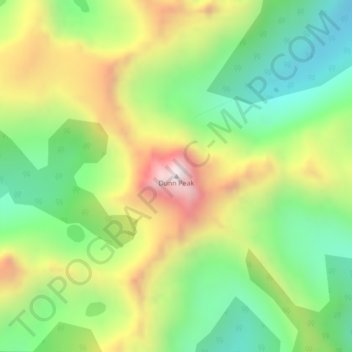
Name: Topografische Karte Dunn Peak, Höhe, Relief.
Durchschnittliche Höhe: 2.132 m
Minimale Höhe: 1.793 m
Maximale Höhe: 2.623 m
Spenden
Andere topografische Karten
Klicken Sie auf eine Karte, um ihre Topografie, ihre Höhe und ihr Relief anzuzeigen.
Community Lake
Canada > British Columbia > Thompson-Nicola Regional District > Area O (Lower North Thompson)
Durchschnittliche Höhe: 1.399 m
Adams Lake
Canada > British Columbia > Thompson-Nicola Regional District > Area O (Lower North Thompson)
According to one account, the lake is 63 kilometres (39 mi) long and 1.6 to 3.2 kilometres (1.0 to 2.0 mi) wide. The surface elevation is 404 metres (1,325 ft) above sea level. The mean depth of 299 metres (981 ft) and maximum depth of 457 metres (1,499 ft) make the second deepest lake in BC (next to Quesnel…
Durchschnittliche Höhe: 1.177 m
Leonie Lake
Canada > British Columbia > Thompson-Nicola Regional District > Area O (Lower North Thompson)
Durchschnittliche Höhe: 1.107 m
Dagger Lake
Canada > British Columbia > Thompson-Nicola Regional District > Area O (Lower North Thompson)
Durchschnittliche Höhe: 1.484 m
Spenden
Spectacle Lake
Canada > British Columbia > Thompson-Nicola Regional District > Area O (Lower North Thompson)
Durchschnittliche Höhe: 1.428 m
Spider Lake
Canada > British Columbia > Thompson-Nicola Regional District > Area O (Lower North Thompson)
Durchschnittliche Höhe: 1.358 m
Bonaparte Lake
Canada > British Columbia > Thompson-Nicola Regional District > Area O (Lower North Thompson)
Durchschnittliche Höhe: 1.383 m