
Spenden
Topografische Karte Manacapuru
Klicken Sie auf die Karte, um die Höhe anzuzeigen.
Spenden
Über diese Karte
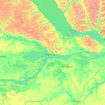
Name: Topografische Karte Manacapuru, Höhe, Relief.
Durchschnittliche Höhe: 33 m
Minimale Höhe: 4 m
Maximale Höhe: 116 m
Spenden
Andere topografische Karten
Klicken Sie auf eine Karte, um ihre Topografie, ihre Höhe und ihr Relief anzuzeigen.
Pico da Neblina
Brazil > Amazonas > Santa Isabel do Rio Negro
For 39 years, based on an uncontested measurement performed in 1965 by topographer José Ambrósio de Miranda Pombo, using a theodolite, the elevation of Pico da Neblina was thought to be 3,014 metres (9,888 ft), but a much more accurate measurement performed in 2004 with state-of-the-art GPS equipment by…
Durchschnittliche Höhe: 2.178 m
Amazon River
Brazil > Amazonas > Careiro da Várzea
During what many archaeologists called the formative stage, Amazonian societies were deeply involved in the emergence of South America's highland agrarian systems. The trade with Andean civilizations in the terrains of the headwaters in the Andes formed an essential contribution to the social and religious…
Durchschnittliche Höhe: 21 m
Spenden
Spenden
Amazon River
During what many archaeologists called the formative stage, Amazonian societies were deeply involved in the emergence of South America's highland agrarian systems. The trade with Andean civilizations in the terrains of the headwaters in the Andes formed an essential contribution to the social and religious…
Durchschnittliche Höhe: 11 m
Spenden
Amazon River
Brazil > Amazonas > Itacoatiara
During what many archaeologists called the formative stage, Amazonian societies were deeply involved in the emergence of South America's highland agrarian systems. The trade with Andean civilizations in the terrains of the headwaters in the Andes formed an essential contribution to the social and religious…
Durchschnittliche Höhe: 11 m
Spenden
Pico da Neblina
Brazil > Amazonas > Santa Isabel do Rio Negro
For 39 years, based on an uncontested measurement performed in 1965 by topographer José Ambrósio de Miranda Pombo, using a theodolite, the elevation of Pico da Neblina was thought to be 3,014 metres (9,888 ft), but a much more accurate measurement performed in 2004 with state-of-the-art GPS equipment by…
Durchschnittliche Höhe: 2.178 m
Spenden
Amazon River
Brazil > Amazonas > Careiro da Várzea
During what many archaeologists called the formative stage, Amazonian societies were deeply involved in the emergence of South America's highland agrarian systems. The trade with Andean civilizations in the terrains of the headwaters in the Andes formed an essential contribution to the social and religious…
Durchschnittliche Höhe: 21 m
Spenden
Espirito Santo
Brazil > Amazonas > Santa Isabel do Rio Negro > Santa Isabel do Rio Negro
Durchschnittliche Höhe: 39 m
Ilha de Curupira
Brazil > Amazonas > Santa Isabel do Rio Negro > Santa Isabel do Rio Negro
Durchschnittliche Höhe: 35 m
Spenden
Presidente Figueiredo
Brazil > Amazonas > Presidente Figueiredo > Presidente Figueiredo
Durchschnittliche Höhe: 111 m
Spenden
Spenden