
Topografische Karte Van Limburg Stirum Kanaal
Interaktive Karte
Klicken Sie auf die Karte, um die Höhe anzuzeigen.
Über diese Karte
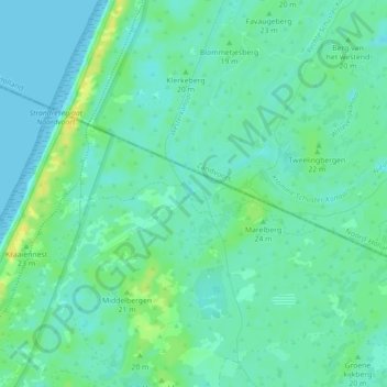
Name: Topografische Karte Van Limburg Stirum Kanaal, Höhe, Relief.
Durchschnittliche Höhe: 7 m
Minimale Höhe: 0 m
Maximale Höhe: 21 m
Andere topografische Karten
Klicken Sie auf eine Karte, um ihre Topografie, ihre Höhe und ihr Relief anzuzeigen.
Noordwijk
Nederland > Zuid-Holland > Noordwijk
Noordwijk, Zuid-Holland, Nederland
Durchschnittliche Höhe: 1 m
Noordwijkerhout
Nederland > Zuid-Holland > Noordwijk
Noordwijkerhout, Noordwijk, Zuid-Holland, Nederland
Durchschnittliche Höhe: 2 m
De Zilk
Nederland > Zuid-Holland > Noordwijk
De Zilk, Noordwijk, Zuid-Holland, Nederland
Durchschnittliche Höhe: 2 m
De Zilk
Nederland > Zuid-Holland > Noordwijk > De Zilk
De Zilk, Noordwijk, Zuid-Holland, Nederland, 2191, Nederland
Durchschnittliche Höhe: 3 m
Westhoek
Nederland > Zuid-Holland > Noordwijk
Westhoek, Noordwijk, Zuid-Holland, Nederland, 2191AX, Nederland
Durchschnittliche Höhe: 6 m