
Topografische Karte Andrews
Interaktive Karte
Klicken Sie auf die Karte, um die Höhe anzuzeigen.
Über diese Karte
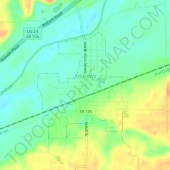
Name: Topografische Karte Andrews, Höhe, Relief.
Ort: Andrews, Huntington County, Indiana, United States (40.85260 -85.61176 40.86951 -85.59269)
Durchschnittliche Höhe: 224 m
Minimale Höhe: 208 m
Maximale Höhe: 250 m
Andere topografische Karten
Klicken Sie auf eine Karte, um ihre Topografie, ihre Höhe und ihr Relief anzuzeigen.
Mount Etna
United States > Indiana > Huntington County
Mount Etna, Huntington County, Indiana, United States
Durchschnittliche Höhe: 245 m
Huntington
United States > Indiana > Huntington County > Huntington
Huntington, Huntington County, Indiana, 46750, United States
Durchschnittliche Höhe: 238 m
Markle
United States > Indiana > Huntington County > Markle
Markle, Huntington County, Indiana, United States
Durchschnittliche Höhe: 244 m