
Topografische Karte Oxford
Interaktive Karte
Klicken Sie auf die Karte, um die Höhe anzuzeigen.
Über diese Karte
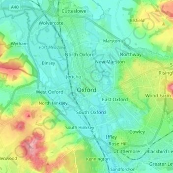
Name: Topografische Karte Oxford, Höhe, Relief.
Ort: Oxford, Oxfordshire, England, United Kingdom (51.71098 -1.30425 51.79627 -1.17581)
Durchschnittliche Höhe: 81 m
Minimale Höhe: 50 m
Maximale Höhe: 170 m
Andere topografische Karten
Klicken Sie auf eine Karte, um ihre Topografie, ihre Höhe und ihr Relief anzuzeigen.
Banbury
United Kingdom > England > Oxfordshire > Cherwell District
Banbury, Cherwell District, Oxfordshire, England, United Kingdom
Durchschnittliche Höhe: 116 m
Witney
United Kingdom > England > Oxfordshire > West Oxfordshire > Witney
Witney, West Oxfordshire, Oxfordshire, South East England, England, United Kingdom
Durchschnittliche Höhe: 92 m
Oxford
United Kingdom > England > Oxfordshire > Oxford
Oxford, Oxfordshire, South East England, England, OX1 3HY, United Kingdom
Durchschnittliche Höhe: 81 m