
Topografische Karte Campbell County
Interaktive Karte
Klicken Sie auf die Karte, um die Höhe anzuzeigen.
Über diese Karte
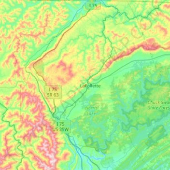
Name: Topografische Karte Campbell County, Höhe, Relief.
Ort: Campbell County, Tennessee, United States of America (36.17699 -84.37678 36.59218 -83.89953)
Durchschnittliche Höhe: 473 m
Minimale Höhe: 249 m
Maximale Höhe: 1.063 m
Campbell County is situated amidst a geological border region between the Cumberland Plateau in the northwest and the Appalachian Ridge-and-Valley Range in the southeast. This border area is characterized by several large, elongate ridges, namely Cross Mountain in the west and Cumberland Mountain, Walnut Mountain, and Pine Mountain to the north. Ivydale, situated in the Plateau region, is the exact geographical center of Campbell County. Elevations vary widely across the county, ranging from 3,534 feet (1,077 m) at Cross Mountain to slightly less than 1,000 feet (300 m) a few miles away at Norris Lake. Norris Lake— an artificial reservoir created by the Tennessee Valley Authority in the 1930s— is the main body of water in the region. It is fed by the Clinch and Powell rivers as well as several large creeks, most notably Davis Creek, Big Creek, and Cove Creek. Cove Creek also feeds the much smaller Cove Lake— a recreational lake built by TVA in the 1930s as part of the Norris project— which is located near Caryville.
Andere topografische Karten
Klicken Sie auf eine Karte, um ihre Topografie, ihre Höhe und ihr Relief anzuzeigen.
Douglas Lake
United States of America > Tennessee > Dandridge > Sugar Forks
Douglas Lake, Crickett Drive, Sugar Forks, Dandridge, Jefferson County, Tennessee, 37725, United States of America
Durchschnittliche Höhe: 370 m
Bell Buckle
United States of America > Tennessee > Bell Buckle
Bell Buckle, Bedford County, Tennessee, United States of America
Durchschnittliche Höhe: 264 m
Cades Cove
United States of America > Tennessee > Cades Cove
Cades Cove, Blount County, Tennessee, United States of America
Durchschnittliche Höhe: 656 m
Forest Heights
United States of America > Tennessee > Forest Heights
Ford, Forest Heights, Loudon County, Tennessee, 37772, United States of America
Durchschnittliche Höhe: 285 m
Tilson Branch
United States of America > Tennessee
Tilson Branch, Unicoi County, Tennessee, 36657, United States of America
Durchschnittliche Höhe: 716 m
Harrogate
United States of America > Tennessee > Harrogate
Harrogate, Claiborne County, Tennessee, United States of America
Durchschnittliche Höhe: 416 m
Cumberland Heights
United States of America > Tennessee > Nashville-Davidson > Cumberland Heights
Cumberland Heights, Nashville-Davidson, Davidson County, Tennessee, 37207-4405, United States of America
Durchschnittliche Höhe: 143 m
Backwoods
United States of America > Tennessee > Backwoods
Backwoods, Carter County, Tennessee, United States of America
Durchschnittliche Höhe: 1.139 m
Halfway
United States of America > Tennessee > Halfway
Halfway, Cumberland County, Tennessee, 37770:38571, United States of America
Durchschnittliche Höhe: 466 m
Birds Creek
United States of America > Tennessee
Birds Creek, Henry County, Tennessee, United States of America
Durchschnittliche Höhe: 173 m
Wartburg
United States of America > Tennessee > Wartburg
Wartburg, Morgan County, Tennessee, United States of America
Durchschnittliche Höhe: 404 m
House Mountain
United States of America > Tennessee
House Mountain, Knox County, Tennessee, 37806, United States of America
Durchschnittliche Höhe: 396 m