
Topografische Karte Reisterstown
Interaktive Karte
Klicken Sie auf die Karte, um die Höhe anzuzeigen.
Über diese Karte
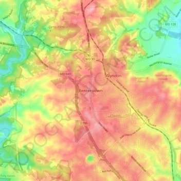
Name: Topografische Karte Reisterstown, Höhe, Relief.
Durchschnittliche Höhe: 183 m
Minimale Höhe: 114 m
Maximale Höhe: 233 m
Andere topografische Karten
Klicken Sie auf eine Karte, um ihre Topografie, ihre Höhe und ihr Relief anzuzeigen.
Catonsville
United States > Maryland > Baltimore County
Catonsville, Baltimore County, Maryland, 21228, United States
Durchschnittliche Höhe: 104 m
Hereford
United States > Maryland > Baltimore County
Hereford, Baltimore County, Maryland, United States
Durchschnittliche Höhe: 170 m
Perry Hall
United States > Maryland > Baltimore County
Perry Hall, Baltimore County, Maryland, 21236, United States
Durchschnittliche Höhe: 72 m
Dundalk
United States > Maryland > Baltimore County
Dundalk, Baltimore County, Maryland, 21222, United States
Durchschnittliche Höhe: 33 m
Cockeysville
United States > Maryland > Baltimore County
Cockeysville, Baltimore County, Maryland, 21031, United States
Durchschnittliche Höhe: 131 m
Kingsville
United States > Maryland > Baltimore County
Kingsville, Baltimore County, Maryland, 21087, United States
Durchschnittliche Höhe: 83 m
Hydes
United States > Maryland > Baltimore County > Towson
Hydes, Towson, Baltimore County, Maryland, 21013, United States
Durchschnittliche Höhe: 123 m
Upperco
United States > Maryland > Baltimore County
Upperco, Baltimore County, Maryland, 21155, United States
Durchschnittliche Höhe: 218 m
Jacksonville
United States > Maryland > Baltimore County
Jacksonville, Baltimore County, Maryland, 21131, United States
Durchschnittliche Höhe: 170 m
Edgemere
United States > Maryland > Baltimore County
Edgemere, Baltimore County, Maryland, 21219, United States
Durchschnittliche Höhe: 4 m
Randallstown
United States > Maryland > Baltimore County
Randallstown, Baltimore County, Maryland, 21133, United States
Durchschnittliche Höhe: 151 m
Maryland Line
United States > Maryland > Baltimore County
Maryland Line, Baltimore County, Maryland, 21105, United States
Durchschnittliche Höhe: 244 m
Oregon
United States > Maryland > Baltimore County
Oregon, Baltimore County, Maryland, 21031, United States
Durchschnittliche Höhe: 136 m
Honeygo
United States > Maryland > Baltimore County
Honeygo, Baltimore County, Maryland, 21162, United States
Durchschnittliche Höhe: 47 m
Riderwood
United States > Maryland > Baltimore County
Riderwood, Baltimore County, Maryland, 21139, United States
Durchschnittliche Höhe: 106 m
Lutherville
United States > Maryland > Baltimore County
Lutherville, Baltimore County, Maryland, 21204, United States
Durchschnittliche Höhe: 117 m
Milford Mill
United States > Maryland > Baltimore County
Milford Mill, Baltimore County, Maryland, 21244, United States
Durchschnittliche Höhe: 139 m
Boring
United States > Maryland > Baltimore County
Boring, Baltimore County, Maryland, 21020, United States
Durchschnittliche Höhe: 193 m
Butler
United States > Maryland > Baltimore County
Butler, Baltimore County, Maryland, 21023, United States
Durchschnittliche Höhe: 134 m
Shepperd
United States > Maryland > Baltimore County
Shepperd, Baltimore County, Maryland, 21111, United States
Durchschnittliche Höhe: 175 m
Relay
United States > Maryland > Baltimore County
Relay, Baltimore County, Maryland, 21227, United States
Durchschnittliche Höhe: 40 m
White Hall
United States > Maryland > Baltimore County
White Hall, Baltimore County, Maryland, 21161, United States
Durchschnittliche Höhe: 146 m
Arbutus
United States > Maryland > Baltimore County
Arbutus, Baltimore County, Maryland, 21227, United States
Durchschnittliche Höhe: 57 m
Fork
United States > Maryland > Baltimore County > Kingsville
Fork, Kingsville, Baltimore County, Maryland, 21051, United States
Durchschnittliche Höhe: 120 m
Hart-Miller Island State Park
United States > Maryland > Baltimore County
Hart-Miller Island State Park, Baltimore County, Maryland, United States
Durchschnittliche Höhe: 1 m
Hampton
United States > Maryland > Baltimore County
Hampton, Baltimore County, Maryland, 21286, United States
Durchschnittliche Höhe: 118 m
Overlea
United States > Maryland > Baltimore County
Overlea, Baltimore County, Maryland, 21026, United States
Durchschnittliche Höhe: 64 m
Brooklandville
United States > Maryland > Baltimore County > Towson
Brooklandville, Towson, Baltimore County, Maryland, 21022, United States
Durchschnittliche Höhe: 122 m
Soldiers Delight Natural Environment Area
United States > Maryland > Baltimore County > Owings Mills
Soldiers Delight Natural Environment Area, Red Run Boulevard, Belltown, Owings Mills, Baltimore County, Maryland, 21117, United States
Durchschnittliche Höhe: 187 m
Rossville
United States > Maryland > Baltimore County > Rossville
Rossville, Baltimore County, Maryland, 21326, United States
Durchschnittliche Höhe: 33 m
Marshy Point
United States > Maryland > Baltimore County
Marshy Point, Baltimore County, Maryland, 21027, United States
Durchschnittliche Höhe: 1 m
Middle River
United States > Maryland > Baltimore County > Middle River
Middle River, Baltimore County, Maryland, 21220, United States
Durchschnittliche Höhe: 13 m
Lutherville
United States > Maryland > Baltimore County > Lutherville
Lutherville, Baltimore County, Maryland, United States
Durchschnittliche Höhe: 116 m
Cockeysville
United States > Maryland > Baltimore County > Cockeysville
Cockeysville, Baltimore County, Maryland, United States
Durchschnittliche Höhe: 120 m
Parkville
United States > Maryland > Baltimore County > Parkville
Parkville, Baltimore County, Maryland, 21234, United States
Durchschnittliche Höhe: 111 m
Parkton
United States > Maryland > Baltimore County
Parkton, Baltimore County, Maryland, 21120, United States
Durchschnittliche Höhe: 166 m
Pikesville
United States > Maryland > Baltimore County > Pikesville
Pikesville, Baltimore County, Maryland, United States
Durchschnittliche Höhe: 135 m
Carney
United States > Maryland > Baltimore County > Oakleigh
Carney, Oakleigh, Baltimore County, Maryland, United States
Durchschnittliche Höhe: 103 m
Essex
United States > Maryland > Baltimore County
Essex, Baltimore County, Maryland, 21221, United States
Durchschnittliche Höhe: 14 m
Baldwin
United States > Maryland > Baltimore County
Baldwin, Baltimore County, Maryland, 21082, United States
Durchschnittliche Höhe: 130 m
Dundalk
United States > Maryland > Baltimore County > North Point Village
Dundalk, North Point Village, Baltimore County, Maryland, 21222, United States
Durchschnittliche Höhe: 6 m
Yeoho
United States > Maryland > Baltimore County
Yeoho, Baltimore County, Maryland, 21023, United States
Durchschnittliche Höhe: 180 m
Kingsville
United States > Maryland > Baltimore County > Kingsville
Kingsville, Baltimore County, Maryland, 21087, United States
Durchschnittliche Höhe: 85 m
Arbutus
United States > Maryland > Baltimore County > Relay
Arbutus, Relay, Baltimore County, Maryland, United States
Durchschnittliche Höhe: 42 m
Hoffmanville
United States > Maryland > Baltimore County > Hoffmanville
Hoffmanville, Baltimore County, Maryland, 21088, United States
Durchschnittliche Höhe: 223 m
Timonium
United States > Maryland > Baltimore County > Timonium
Timonium, Baltimore County, Maryland, United States
Durchschnittliche Höhe: 113 m
White Marsh
United States > Maryland > Baltimore County > White Marsh
White Marsh, Baltimore County, Maryland, United States
Durchschnittliche Höhe: 39 m
Pikesville
United States > Maryland > Baltimore County
Pikesville, Baltimore County, Maryland, 21208, United States
Durchschnittliche Höhe: 141 m
Bowleys Quarters
United States > Maryland > Baltimore County > Bowleys Quarters
Bowleys Quarters, Baltimore County, Maryland, United States
Durchschnittliche Höhe: 2 m
Glyndon
United States > Maryland > Baltimore County
Glyndon, Baltimore County, Maryland, 21136, United States
Durchschnittliche Höhe: 183 m