
Spenden
Topografische Karte Pitogo
Klicken Sie auf die Karte, um die Höhe anzuzeigen.
Spenden
Pitogo
The fact that Pitogo is built on a promontory of rolling hills has a great rationale behind. Historical records show that this site was selected by the town's founders in 1766 because its lofty elevation provided them with good look out points for the marauding vintas of Muslim pirates who were then threatening the safety of the natives.
Spenden
Über diese Karte
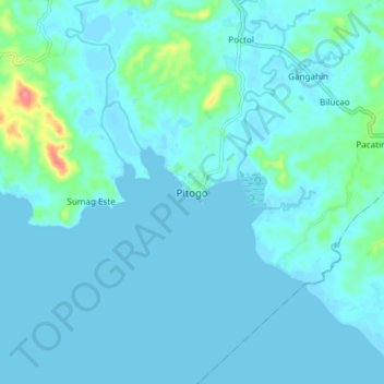
Name: Topografische Karte Pitogo, Höhe, Relief.
Ort: Pitogo, Quezon, Calabarzon, 4308, Philippines (13.74324 122.04779 13.82324 122.12779)
Durchschnittliche Höhe: 9 m
Minimale Höhe: -4 m
Maximale Höhe: 80 m
Spenden
Andere topografische Karten
Klicken Sie auf eine Karte, um ihre Topografie, ihre Höhe und ihr Relief anzuzeigen.
Sariaya
Sariaya is situated on a flat land except for a portion on the north occupying a part of the foot of Mount Banahaw. The municipality has the highest point of elevation on 3,800 feet above sea level at Barangays Concepcion Banahaw and Sampaloc Bogon.
Durchschnittliche Höhe: 117 m
Spenden
Spenden
Spenden
Spenden
Spenden
Spenden
Spenden
Spenden
Spenden
Spenden
Spenden
Laguna-Quezon Land Grant Lagoon
Philippines > Quezon > Real > Magsaysay > Maunlad
Durchschnittliche Höhe: 389 m
Spenden
Spenden
Sariaya
Sariaya is situated on a flat land except for a portion on the north occupying a part of the foot of Mount Banahaw. The municipality has the highest point of elevation on 3,800 feet (1,200 m) above sea level at Barangays Concepcion Banahaw and Sampaloc Bogon.
Durchschnittliche Höhe: 117 m
Spenden
Spenden
Spenden
Spenden
Spenden
Spenden