
Spenden
Topografische Karte Smithfield
Klicken Sie auf die Karte, um die Höhe anzuzeigen.
Spenden
Smithfield
Established in 1836, Smithfield was the first major settlement of the Fairfield LGA. The original 1838 summary plan of Smithfield shows the suburb laid out in a grid pattern with most of the streets having the same names as they do today. Its altitude ranges from 21 to 48 m (69 to 157 ft) above sea level. Geologically, the suburb sits on the Cumberland Plain. The suburb is a mix of residential, industrial and commercial areas, but is mostly characterized by low-density housing.
Spenden
Über diese Karte
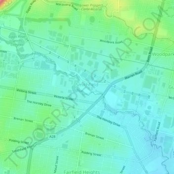
Name: Topografische Karte Smithfield, Höhe, Relief.
Durchschnittliche Höhe: 33 m
Minimale Höhe: 10 m
Maximale Höhe: 111 m
Spenden
Andere topografische Karten
Klicken Sie auf eine Karte, um ihre Topografie, ihre Höhe und ihr Relief anzuzeigen.
Spenden
Spenden
Spenden
St Leonards Park
Australia > New South Wales > Sydney > North Sydney
In 2018 it was announced that North Sydney Council would commence an upgrade of the park including improving the war memorial with a reflection pool, restoration of the Tunks Fountain and elevation on a new plinth, new benches, picnic tables, barbecues and drinking fountains, upgrades to lighting, additional…
Durchschnittliche Höhe: 61 m
Spenden
Spenden
Spenden
Spenden
Spenden
Spenden
Spenden
Spenden
Spenden
Spenden
Spenden
Spenden
Spenden
Spenden
Spenden
Spenden
Spenden
Spenden
Spenden
Spenden
Spenden
Spenden