
Spenden
Topografische Karte Mount Nangtud
Klicken Sie auf die Karte, um die Höhe anzuzeigen.
Spenden
Mount Nangtud
Mount Nangtud is the second highest peak on the island of Panay, in the Philippines and third highest mountain in the Visayas, after Mount Kanlaon and Mount Madja-as. With an elevation of 2,074 m (6,804 ft) above sea level, it is located geographically within Jamindan, Capiz bordering with Barbaza, Antique. Mount Nangtud is famous for its "sea of clouds" and rich for its diverse flora and fauna and mossy forest. It is part of the Central Panay Mountain Range, the longest and largest mountain range in Panay and Western Visayas.
Spenden
Über diese Karte
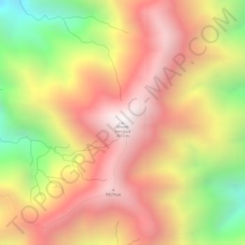
Name: Topografische Karte Mount Nangtud, Höhe, Relief.
Ort: Mount Nangtud, Jamindan, Capiz, Western Visayas, Philippines (11.26787 122.20595 11.26797 122.20605)
Durchschnittliche Höhe: 1.578 m
Minimale Höhe: 888 m
Maximale Höhe: 2.034 m
Spenden
Andere topografische Karten
Klicken Sie auf eine Karte, um ihre Topografie, ihre Höhe und ihr Relief anzuzeigen.