
Vielen Dank für die Unterstützung dieser Website ❤️
Spenden
Spenden
Topografische Karte Amarnath Cave Temple
Klicken Sie auf die Karte, um die Höhe anzuzeigen.
Vielen Dank für die Unterstützung dieser Website ❤️
Spenden
Spenden
Amarnath Cave Temple
Amarnath Temple is a Hindu shrine located in the Pahalgam tehsil of the Anantnag district of Jammu and Kashmir, India. It is a cave situated at an altitude of 3,888 m (12,756 ft), about 168 km from Anantnag city, the district headquarters, 141 km (88 mi) from Srinagar, the summer capital of Jammu and Kashmir, reached through either Sonamarg or Pahalgam. It is an important shrine in Hinduism.
Vielen Dank für die Unterstützung dieser Website ❤️
Spenden
Spenden
Über diese Karte
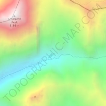
Name: Topografische Karte Amarnath Cave Temple, Höhe, Relief.
Durchschnittliche Höhe: 4.325 m
Minimale Höhe: 3.719 m
Maximale Höhe: 5.200 m
Vielen Dank für die Unterstützung dieser Website ❤️
Spenden
Spenden